Great Basin
A Gulch in the
Escalante Desert
Notes from Hole in the Rock Road
in Utah's Sublime Escalante Region
The Los Angeles Central Library is a shrine among the lines of tents, sleeping bags and garbage cans of downtown Los Angeles. A grand structure of depth and long gray walls, stories of books. Books, stone, and readers among the homeless, the jewelry hawkers, the law firms. The eloquence of the library - steep, narrow, dark. Like a canyon, the way the light bounces down the walls.
Paul Theroux is speaking on the history of fiction and non-fiction in Honolulu. Theroux has been attributed for injecting the vacuous genre of travel writing with a sense of truth. Decline had said goodbye to Twain, Borges, Conrad, Maugham, Stephenson. It had become 'The Best Ten Hotels in Las Vegas!', and bumbling English gentlemen on Safari.
Attracted by his travel non-fictions and fictions since eleven (he winced in partial-insult when I told him this), I have come here to observe his audience, which I suspected would be a rare cross-section of young travelers, mischief-makers and aspiring writers. What I find is aging peace-corps renegades, literary snobs and wrinkled bookworms.
"Are you a traveler?" a lady in a hat asked me. Another said, "the Book Faire is the real thing. I met Salman Rushdie."
Another asked Theroux, "How are you able to write both fiction and non-fiction?"
"Travel writing is easy. You have a beginning, a middle and a destination already prepared for you. The end is already written."

Bryce Canyon NP, Utah
I slip into the streets, then into the desert, then Nevada, Arizona, and Utah. But not before I rip apart my itinerary, the beginning, the middle and the end.
Too much structure in travel is dangerous - because it creates expectations. Tourists seek structure - maybe they only have two weeks a year to get it right, so why not? But I don't have a timeline; I don't need to create the perfect experience. The perfect experience is a myth anyway, because most of travel is sweat and lost luggage.
To define my route would be to seek something; to quest for what I knew before I left. To leave things open is to allow myself open to discovery.
Sometimes people like to add novelty to their travel; finding GPS waypoints, carrying with them a can of beans and photographing by national monuments, claiming themselves proponents of 'anti-travel' and doing everything they can to do things differently.
I see travel as experimental enough in itself to not need any novelty. Those novelties, anyway, are the kinds of things the traveler carries with him. Travel should shed as much as home as possible. Let what may happen, happen.

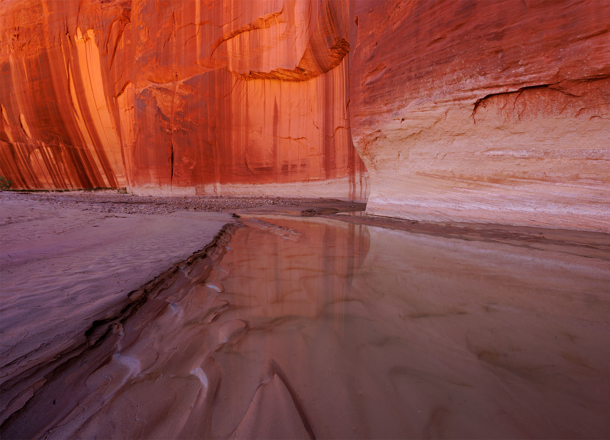
Calf Creek, Escalante NM, Utah
I formulate a rough structure for where I am going: somehow to complete the so-called Grand Staircase - a region in Utah and Arizona, by car, by foot and by water, in no particular order. This is a series of steps that begin in the north at nine thousand feet, and drop slowly, in a collection of vast twisting drainages that eventually become the Grand Canyon.
Each step of the Staircase is suitably different, getting weirder on the way south. Kind of like Dante's Inferno - each step gets hotter, until the lowest elevations, where the heat bakes above a cold, gray canyon bottom, and the flies are unbearable.
The first step, the high plains of Bryce Canyon ('Helluva place to lose a cow,' noted Ebenezer Bryce), is filled with German tourists, marching in long single columns. Some are curious about my camera, sniffing at it, and putting their eye against the lens. This is Dante's Limbo, I thought, because I like German tourists.

Claret Cup Cactuses have one of the most incredible desert blooms.
To explore the geology of this, the Colorado Plateau and its staircase, let's visit an imaginary desert grocery store, with a shopping list: 1. One slice ham., 2. One leaf lettuce., 3. One slice salami., 4. One turnip., 5. One slice roast beef., 6. One bottle mustard, yellow., 7. One prickly-pear cactus-head, de-thorned., 8. One bottle peanut butter., 9. One slice pepperoni., 10. One avocado., 11. Chocolate spread, dark., 12. One slice, roast beef., 13. One bottle, mayo-mustard., 14. One slice, pastrami, thick., 15. One bottle, brown mustard., 16. green onions, minced., 17. One thin carrot.
We
are going to assemble a giant sandwich - with the carrot on the bottom,
to the south end of our meal, creating a bump in the layers we place carefully,
until we get to the ham, on the top.
Now let's forget about our sandwich, and go back to the time before sliced
bread. One hundred and forty-four million years ago, when North America
was split in two, by a giant sea which connected the Arctic to the Caribbean,
by way of Utah. We call this body of water the Cretaceous Seaway.
Silt,
sand, dirt, dust and debris visited this sea from the formation of the
Rocky Mountains, from California's forming ranges, creating thousands
of feet of layers - sedimentation turned to stone.
These layers - like the iron-red Triassic-silts, the lime of the pink
cliffs, the gray of marine rock, are our sandwich.
We are going to cut each layer back with our x-acto blade, until our sandwich looks like a madman's cascade, a staircase if you will, with a bump. We then take an x-acto blade and slice the bump over the carrot down the middle, to the bottom. We will call this split, with each of the rich layers of food showing through, the Grand Canyon.
We will leave our sandwich in the desert for a few days, so the peanut butter and mustard dry and crack. We will run bleach down the cascade, imagining bleach to be millions of years of water erosion. The bleach will run down the cascade, creating ruts, sometimes leaving a layer intact, like a natural bridge; canyons, arches, bumps of dried meats which we call buttes.
We have just made the world's first biodegradable scale-model of the Colorado Plateau, its Grand Staircase, which I have just hopped down. I am now in the Wraithful & Sullen (One slice pepperoni), also known as Escalante.

More specifically, I am on the edge of Forty-Mile Ridge, plunging vertically into the Escalante River, which at this point, is still-water. Lake Powell, Glen Canyon Dam. Edward Abbey imagined blowing the dam to bits. Man, after all, can't micromanage nature. Damning the main drainage of the west coast has wreaked havoc on the Southwest, on Desert Mexico, on the Sea of Cortez. I like Edward Abbey. Sometimes I wish he did blow it up.
The sky turns black. The storm from Baja has arrived, ahead of schedule. The temperature drops. Rain.
There are no trees on the plateau, just miles of slickrock. There is no shade. If lightning strikes, I am the tallest object in ten miles. I also carry 40 pounds of metal on my back. I begin to run. It is about four miles, all uphill slog through sand, to the mesa where I have parked the truck. The first lightning strikes on Fifty-Mile Bench, ten miles away.
The second strikes just past the mesa, near the Mormon trail.
The third lightning strike is just a flash of white light all around me, a white that turns my hair on end, shocking my pupils. I run, like a mad, stupid coward to the truck, and jump in.
see myself in the truck's mirror. But the face I see is black with sun, drenched in rain and sweat, the under-eyes are blue, with veins popping, and the nose and ears are rutty and exposed from sun. I am panting like a dog, my nose is bleeding. Things could be worse, I could be sitting on a couch, with three or four guys with their hands down their pants, watching the Lakers, talking about mortgages and the prices of cell phone service.
When the clouds pass over the Escalante Canyons, and the evening desert sun again beats down on the mesa, I walk out and look in every direction. The south - mountain. West and east - bald rock. It is fifty miles to Escalante, and because of the rain, I am trapped here until the road dries.
I walk around the truck, throw some rocks. Try to pick up trash around the trailhead. There is none. I boil five potatoes, more than I need. And cut onions, garlic, red peppers. I am a chef deep in the desert, and waiting for my unsuspecting patrons to appear from the end of a dark hollow. They will be a large group, and bored of each other's company. They will desire nothing more than fresh food, a break from freeze-dried Thai chicken soup, protein bars and gorp.
I will be ever willing to serve up their meal. And would you like some green onions with that?
But the young clan never shows, the sky clouds over, and I am alone on a mesa, with a small flame illuminating the slickrock, watching the storm and an occasional lightning strike move on to Moab.
I sit in the sand for some hours, waiting. But for what, I do not know. Solitude is like shadow-boxing. The more you fight it, the more you realize you are bullying your own conflicts. Then the coyotes start, their howls echoing off the slickrock, the canyons. I am haunted.
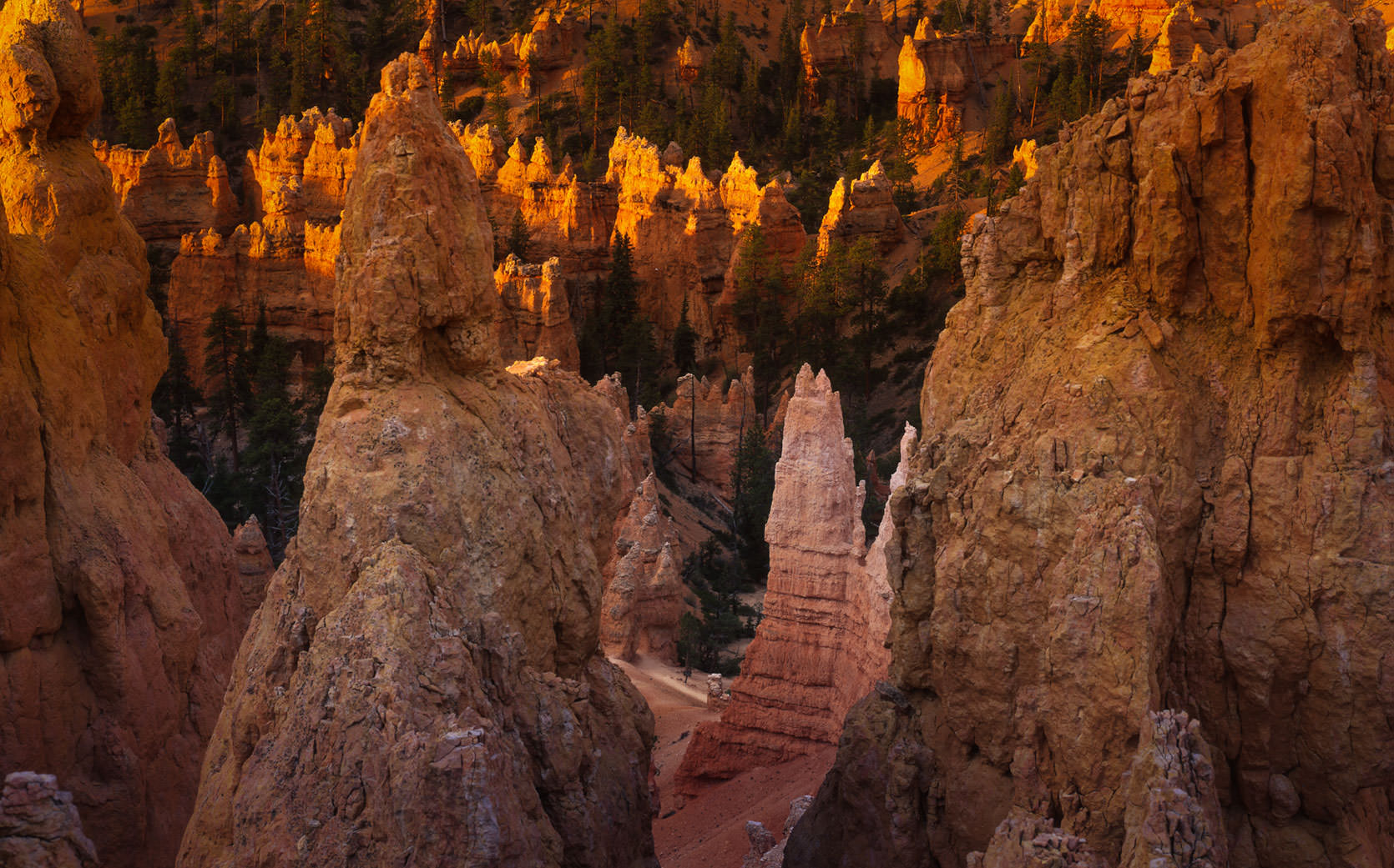
Bryce Canyon National Park in Utah. The highest point in a series of geological steps. In these notes, I travel from here to Escalante, Utah.
At some point, I get the courage to open a book. Books in the desert lose their moisture and become thin, crisp. Their pages smell of pulp, like long-shelved tomes in libraries. In this manner, they are comforting. Soon, I am lost in a café in Tangiers, in 1922. I have forgotten my guests, who never showed. I read Edward Marriott, Edward Abbey, and an essay by David Ouammen, on Terry Tempest Williams, and a chapter by Terry Tempest Williams, on Edward Abbey.
The next week in solitude on a lonely mesa, I have forgotten my first night in Escalante. I am five miles in the desert, with guidebooks: geology, a bird book, a plant life book. Two books on reptiles, and one on cactus species. I am now familiar with the identification of globemallows, horsewhips, beavertails. The very blue collard lizard is easy to spot. I can distinguish the western from the eastern fence lizard.
I am on the edge of a great crevice in the earth; a desert canyon, with a harness and a rope attached to a smooth rock. One jump, one short rappel. I land on the sandy bottom, and pull the rope from the rock. When it finally slides limp into the sand, I feel a shock; the way my body reacted after my first earthquake. When I let that rope slide, I am cutting myself off from my fears - the solitude, the quiet, the coyotes. I have overcome this thing about solitude. I have books.
Solitude is a long paragraph; a rambling thought. It is also a complete book. Lonely people, I thought, cannot endure solitude. Lonely people need people all the time. But I need space; to reflect on my future, to reflect on back there. To make decisions. I also need the desert, because the desert is barren. Emptiness sparks the imagination; cleanliness and subtlety make thought clear. Every part of the desert has an evil to it: the barbs, the stingers, the armor, the bare stone. But the desert is subtle, and clean.
Charles
Darwin once commented on this. In The Voyage of the Beagle (1836), he
writes,
In calling up images of the
past, I find that the plains of Patagonia frequently cross before my eyes;
yet these plains are pronounced by all wretched and useless. They can
be described only by negative characters; without habitations, without
water, without trees, without mountains, they support merely a few dwarf
plants. Why then, and the case is not peculiar to myself, have these arid
wastes taken so firm a hold on my memory? I can scarcely analyze these
feelings: but it must be parly owing to the free scope given to the imagination.
The plains of Patagonia are boundless, for they are scarcely passable,
and hence unknown: they bear the stamp of having lasted, as they are now,
for ages, and there seems no limit to their duration through future time.

White House Trailhead, Escalante, Utah
I
drive to Calf Creek, north of Escalante, and find a coffee shop overlooking
the river - a view of the canyons. I am the only guest.
It is the Kiva
Coffeehouse's first day of business. Red earth, pillars of douglas fir,
wooden chairs, built on site. "I'm sorry but our coffee machine is
broken. No mocha, no cappuccino."
"Regular coffee is fine."
"And we don't have any desserts. Don't look at the dessert menu."
Granddaughter was the waitress. She was apologizing for everything.
"Oh, let me wash that knife for you. It's not dirty, those are just
dishwasher stains."
"Don't bother," I said, "I haven't used silverware in days."
"How about…"
"It's on the menu, but, sorry, we don't have it."
"What do you recommend?"
"The quesadilla."
"My favorite."
"Very well."
Granddaughter, and daughter, had just reopened Kiva Coffeehouse. I gathered
that Father had died shortly after the coffeehouse opened, that daughter
and granddaughter had moved back to Cedar City to reinvent life, that
Kiva Coffeehouse burned in the sun for three years until the two of them
had left ordinary life to begin an adventure and complete father's dream.
Father was a genius, and also Mr. And Mrs. Albert Einstein's interpreter
for ten years. He had become a master in Japanese gardens, and still dreamed
of the Southwest, which he first witnessed at the age of nineteen.
They
both look young for their age - that eternal look of people in Utah -
healthy, innocent, with good air to breathe. So many city people are pickled
from alcohol by age fifty, burnt and wrinkled from sun and smoke; the
youthfulness is almost a spectacle: "We have a ranch in the Escalante
canyons," said granddaughter, seating herself at my table.
"I saw two snakes last night," I said, "I hate snakes,
they scare me."
"When I was in high-school, we were swimming in the (Escalante) river,
and a water moccasin bit this boy on the hand. They took a knife and slit
off its head, but they couldn't get the head off."
"So what'd they do?"
She explained that they had squished the skull and forced it off the hand.
"He had two holes in his thumb after that."
I said, "I've been hiking in the desert for a couple years now, a
perpetual novice, I am always afraid of snakes. I don't know what to do.
I see them, I go running, I freeze up. Last night, I jumped in a river."
"What kind was it?"
"A racer, I think. Little green thing. They aren't poisonous, but
they bite like mad."
"What was the other one?"
"I knew it wasn't a rattler. But I wasn't sure what it was."
"Gopher snake?"
"I hope so," I said, looking in the guidebook, "but I wasn't
sure, so I tried to get it out of my way. I threw sand on it. That didn't
do anything. Pebbles. He didn't wince at the pebbles. Sticks, nothing
to hurt him, just small ones. Took ten minutes, finally lifted him off
the trail with a stick. I trucked down the trail for about twenty feet.
I kept thinking he was gonna pounce."
She apologized for the coffee.
"The coffee is fine. Are people still upset about Escalante becoming
a monument?" I asked, a rough topic for this area.
"Yes," she said. "If they didn't make it so big, it wouldn't
have been a problem." I wanted to know how the people in Escalante
felt about the Monument. It was obvious that in its fourth year, little
had changed. The hikers and boaters that pass through this area spend
little, and being outdoors-types, are very clean. No more trash on the
streets than before. No trouble.

Calf Creek, Escalante Region, Utah
In 1996, the White House proclaimed eight percent of Utah a National Monument, the second highest level of environmental protection in the United States. The protection would displace 144,000 sheep and 26,000 cattle. The town of Escalante wore black, people cried. Protested.
But unlike what the papers were saying, the whole affair wasn't as simple as Federal Government exercising its control over the state; it was the end product of dozens of years of work, thousands of people's dedication and hard-efforts. The goal of making Escalante a National Monument began in the early twentieth century - it had been shelved in 1938. Even back then, overgrazing was ruining the canyons; silting the floodways.
Protection of Escalante isn't a political issue; it's a natural question of the weight of jobs versus the environment. Anyone can tell you the future of salmon, or whales, or owls squishes the cry of "but my job!" Anybody can get a new job (and jobs in Escalante were subsidized by socialized land - grazing land was on loan), but the structure of ecology is permanent. Now, the sparse tourism is growing the communities, surpassing the value of the sheep, or the cows.
Granddaughter apologizes for my quesadilla. It was the best quesadilla I ever had.
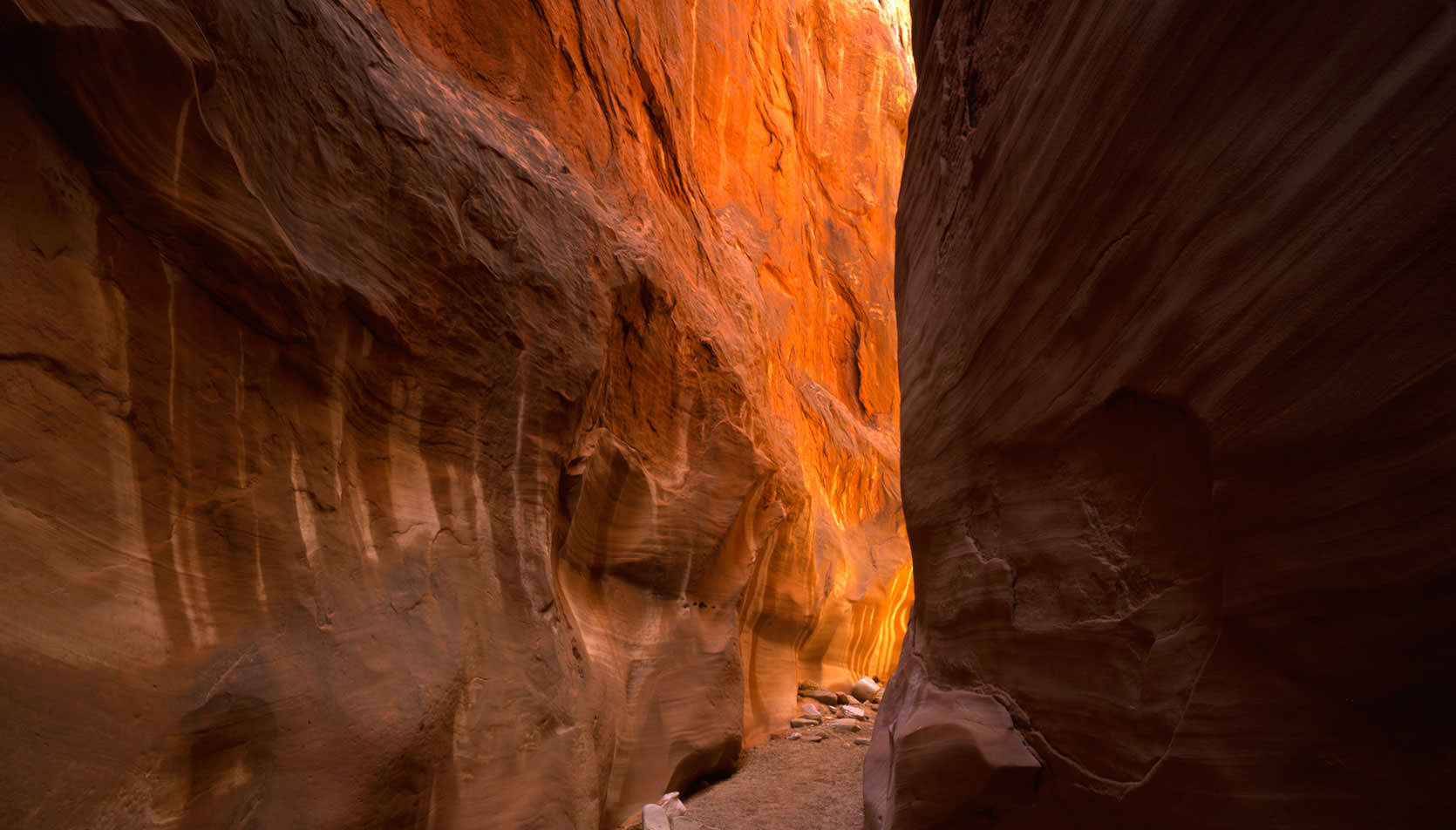
And then I left, to pass through Zion, Kanab, Treachery (One slice, pastrami, thick). The Paria Canyon, a major drainage into the Grand Canyon, is singularly treacherous as most of Southern Utah's rain ends up passing through here. If Bryce is watered on, Paria's narrows receive a wall of water, killing everything in site.

Natural arch in Devil's Playground, Grand-Staircase Escalante, Utah
Paria's elevation and geography make it hot, dry; filled with flys. I am walking down the canyon, looking at the pink and gray canyon walls, the slots, the cracked mud and flooded riverbanks, dreading and desiring the coming end of my solitude, dreading my approach to the Grand Canyon. I stay here for a few days, just kind of wandering about, sitting in my chair, swatting flies.
I am tired, weary. I have no desire to see the Grand Canyon. I thirst for beer, and leave Paria for the North Rim parking lot. Here I begin drinking, watching the people from all over the world march to the view of the Canyon. Many of them walk with their head down. Pale, unsuitably dressed. In a few minutes they will leave again, driving the two or three hundred miles back to wherever they came from.
A man in an outback hat - "Name's Dave." He wants to talk about Escalante, seeing the dirt on my truck. "I got maps," he said, coming back with an armful. I pull out my maps. We sit on the ground. He says, "I've been here for twelve days."
"What do you do?"
"I'm independently poor. I film everywhere I go. Super-eight."
"What do you want to do with all these films?"
"I watch them, listening to music. I really like music. Classical. New age. Jazz. I have a new Astro-Van. Souped it up," he says, pointing to his raised van. "It's got four-wheel drive. Satellite. Cable. The Weather channel. I got cellular. Been working on it. Everything I need. Got a laptop in there. I can pull up maps from this website, print them out."
He added, "You look at all these people. It's always the same story. Families and all their problems."
I said, "As a solo-traveler, you have the luxury to see those sorts of things."
"Absolutely," he said, but I was already wondering why he was traveling alone. "I go everywhere," he says. But he had also mentioned bad times. Had his wife died? Did some lawyer get a hold of him and sue him broke?
When Super-Eight Dave leaves, a young man walks up to my truck, inquiring into the dirt. I say, "Want a beer?"
"Sure. Name's Leo."
"Take a seat, Leo," I say, referring to my cooler, "You got a bad sunburn."
"I'm black."
"I know you're black, look at your arms."
"I've been on the road a while," he said, "too much sun. Sometimes we forget we can get burnt too." And, "Air Force, discharged. Taking some time off."
He said he had served in the Philippines. I asked why he was traveling alone. He said he had a girlfriend in Arizona, and one he met in Manila. "She was from Malaysia. When I found out her family ate monkeys, I left her."
"What happened to the one in Arizona?"
"Gone too long, I guess. Maybe we'll get back."
I said, "see that couple there." It was a family from Texas. The wife is pale, with a short haircut and a long face. The husband, with a squat face and Oakley sunglasses, looks like a bulldog with a moustache. A keystone cop without a club. He is yelling at his children.
Narrow slot canyon.
"You know why he yells at his kids like that?" I said. "His wife is in control. She beats him at night when the kids are asleep."
"Damn, that's good. Let me try one."
A mother, father and daughter walk by. The father wears a collared white shirt. He looks like an accountant, miserable and wanting to be somewhere else.
"Pedophile," Leo whispered, cracking up.
"Leo, you have to be more subtle than that," I said, thinking your girlfriend eats monkeys. "Try again."
"Husband is a very sad man. He goes bowling at night. Hates his wife. She's seeing a senior at her daughter's high school. The best part of his week is the PTA meeting, because he likes the high-school girls in the hallway. But he doesn't know about his wife, because he works late."
"Very good. Another beer?" I say. You're girlfriend eats monkeys. We did this for a while. I was thinking of the luxury of being a solo-traveler, to imagine and take note of the landscape, and its characters.
Another family walks by, heads down. The daughter, young, gawky, clothes too big-fitting, says with a speech impediment, "Mom, dad, I'm going to run ahead to the visitor center. See you there." Leo wanted to comment, but I caught him off guard, "future writer."
"Yeah. Future writer, I like that."

Paria Canyon in early morning light.
Leo
parts, grinning and stumbling. I drive ten miles, and then down to the
view of Point Imperial, watching the sunset over Mount Hayden. A young
lady walks up. "Berkeley. I am getting my masters in Geography."
I quoted an obscure quote, explaining that for the traveler, the map is
everything. About how a thousand pages of words can't do what a map can
do in one.
"Paul Theroux," she said, "One of my favorites."
Stunned, I said, "If you have a map, you don't need an itinerary."
And then the sun set, first over the Vermilion Cliffs, Marble Canyon,
and Kaibab. Then the darkness swallowed Mount Hayden, the layers of the
sandwich, the tributaries of the Colorado River, the South Rim, Flagstaff,
Arizona.