Desert Southwest
Out There in the Anza-Borrego Desert
Road trip through California's cactus-filled desert wonderland.
Ileft Los Angeles in the rain, and when I passed through winding roads of Escondido, I was in Mission Country: great fertile pastures and horses and tiled Spanish churches. After a town of horse-drawn carriages and children playing in the street, the rain grew thicker.
As I rounded a cliff, I saw two bulls fighting on a plateau; and this was a thoroughly stunning scene. But I was getting concerned; the rain was creating a fog as I drove higher into the mountains. Soon, the fog grew to a visibility of 50 feet. Headlights at 70, and on this narrow winding road, this means extreme caution; and so for almost two hours I crept along at 10 miles per hour.
In 1998, El Nino rains padded the Southwest's deserts with moist, fertile sands in an almost scientifically perfect pattern. 3 inches in mid-January. An inch in late January, an inch in February and a slight patter in March. I like to describe the desert as timeless, and barren. Take its sand in the palm of your hand and sift through it - nothing there but sand.
But for a brief moment in the Spring of 1998, that strange event happened in full; California, Arizona and Utah's plains were covered in a carpet of red and yellow and purple and orange and blue wildflowers. Take your hand and look at that sand, it is really filled with wildflower seeds.
And so this year, I planned my travel around this occurance; Joshua Tree in March, Death Valley in April, Tucson in May, and so on and so forth. But La Nina, El Nino's ugly cousin, meant no rain in 1999, and no flowers, so the thought of these clouds reaching into the heart of the Anza-Borrego Basin meant tomorrow morning's yield would be exquisite.
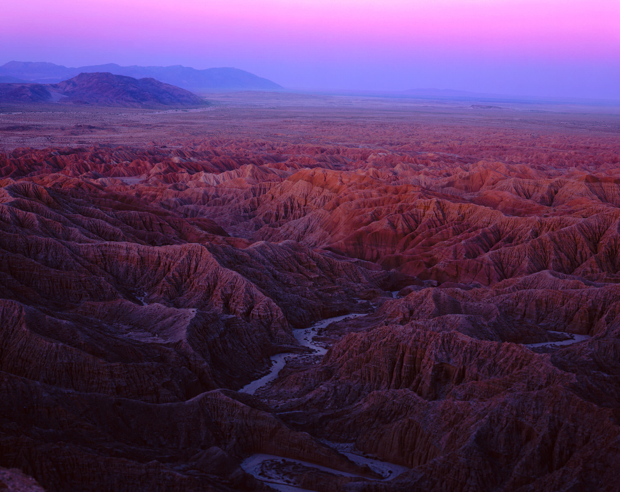
The last turn around the last foggy cliff and - boom - sunshine; the basin was glowing in a late afternoon light. I guess that's why it is a desert - the rain never quite makes it there. The Anza-Borrego Desert State Park is California's largest and least recognized. It is 600,000 square miles of dirt roads and flat horizons. It is named after a man (Anza) and a sheep (Borrego) and is home to thousands of well-preserved petroglyphs and rock art.
I entered through a canyon not quite knowing what to expect. First, the road cut alongside the San Felipe Creek, and then widened into a vast basin of 8,000 foot mountains sloping either side. Catclaw and creosote, and barrel cactus and jumping cholla. One shrub, the spidery ocotillo, was in full red bloom. I crossed some of the paved roads of Anza; back and forth and onto dry wash roads; criscrossing as much territory as I could, until I parked alongside a cliff and climbed it; slowly and carefully as it was lined with sharp plants and instable rocks.
I continued by foot along a promontary and spent the evening looking out over a vast expanse of fishhook cactus and brittlebush - the Yaqui Pass. When the sun dropped, I made my way down the cliffs and on the road again.
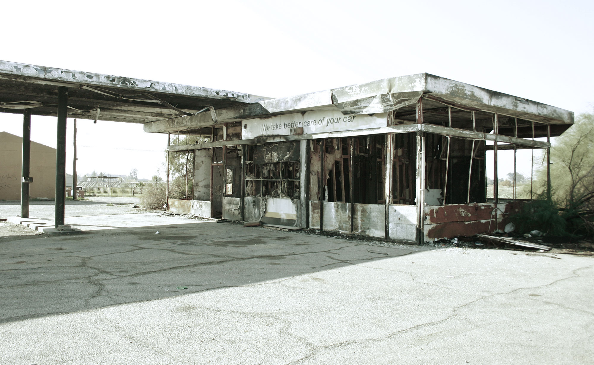
Abandoned gas station along the Salton Sea.
The Ranger's shack was a beaten, dusty office under a Tamarisk Grove. His name was, suitably, Brady. I issued my announcement that I would be camping backcountry, and,
"Can you tell me about the roads here?"
He said, "Do you have four wheel drive."
"Yes."
"Take a seat," he said and poured two glasses of water. He described the farthest off roads, leading to lightly travelled slot canyons and hollows and dry creek beds, and,
"What is this big square here?" I said, pointing to real estate adjacent to the park. "That was a federal bomb site."
"What's it like there?"
"Oh it's wonderful. Red rock, canyons, rivers."
"So you've been there."
"Well, No, I've seen pictures. No one is allowed in there."
"Then how'd you see the pictures?"
"A ranger patrols the area. I met him."
And what about this road and that road and when I said thanks for the help, he kept talking. As I inched for the door, he noticed and said, "Sorry, man, I haven't talked to anybody all day." So I gave him yesterday's Los Angeles Times and my business card; "If you ever go to the federal site, give me a call, I'm interested."
In the dark, I drove along a sand wash, up a mild slope under the Creosote and looked for a spot to pitch camp. It wasn't easy, because the desert camper's worst nightmare is the unlikelihood of rain.
If it were just an inch or so, this whole mountainside could turn into a muddy raging river; and take any tent a mile into the basin. Rule #1, they say, camp where you are immune to the wash, and so I did. With hat and gloves in this 20 degree weather, I ate bread and cheese and bananas on the jeep rooftop.
Since there wasn't a single campfire, flashlight or streetlight within any foreseeable distance, the winter night sky was brilliant. Thank god for all those summers in Bearpaw with a planetologist-to-be and a rocket scientist, because at least I had some faint, faint, faint understanding of what was going on up there.
When the cold got to me, I sat in my car for 3 hours, replaying Dave Matthews and Tim Reynolds songs. I thought: On the Travel Channel, the show host always gets tangled up in exciting scenarios and faces strange odds. For me, the reality is different. The more monotonous, the more predictable, the better I am abiding to my travel plans. And so, I sat there in complete silence. Fumbled with my water bottle. Got out of car and threw rocks. Picked sticks off the ground.
I woke at 5:15, angry for having slept in. I broke camp, and was off to my next location, a strip of below sea-level canyon land that was connected to the largest continuous segment of below-sea level land in the western hemisphere; The Salton Sea. We visited the Salton Sea in late 1998. It was a simple location scout, but I didn't know what I was going to get into. From the car, we raced to the edge of the water.
Lily stopped when the strange smell got to her. I kept going while I watched the soupy water splash against the beachside like oil. The beach went - crunch, crunch, crunch. Soon, I realized the entire beach wasn't sand, but the bones of dead fish. And in the water; algae and hundreds of dying Nile Perch - swimming sideways, hearts pumping, gasping for oxygen, dying.
The Salton Sea was an accident - a botched Colorado River damning project filled California's largest lake in the late 1800's. Farmers filled it with Nile Perch and other fish to eat the algae; rare birds made it home. Losers moved here and claimed it a new eden. Then the reality of environments came, and the algae took the fish by the throat, and now the sea is dying, with Mr. Sonny Bono fighting for its resurrection to his last day. The Salton Sea was eerie; still. You could drop a pin, and it would probably echo.
Here in the Anza basin, that same weirdness overcame me; the haze, the stillness, the ocotillo bobbing in the wind. My last location was a burnt forest along a desert marsh section of the San Felipe, just west of the Park. Soon, I was driving down the foothills, and through miles of Orange groves and barbed wire fences, and finally, to the overcrowded coast.