West Indies

Bakers Bay
and the Eyes of the West Indies
On the Bahamian island of Great Guana Cay, locals prepare to battle a golf course development they say will destroy their coral reef and their way of life.
I am on a boat, tied to a dock in a bay on the tiny island of Great Guana Cay in the Northern Bahamas. Troy Albury is untying lines and points out a Caribbean reef squid taking shelter under the dock.
These animals, hued in purple and electric orange, can be difficult to spot during the day, their bodies are brilliant but translucent.
The mark of a good divemaster is observation - the ability to notice everything. But I am not here to dive with Mr. Albury. When I was young, I dove and snorkeled Great Guana Cay's reef for eight years. But not with Troy. Back then, we were both teenagers, and Troy lived in Nassau, several islands south of the Abaco Islands.
Troy, like many islanders on Great Guana Cay, works barefoot. His t-shirt is frayed at the edges, and his hands are stained faintly with motor grease. A part for one of his boat engines just failed, and so he flew to Miami and bought two tickets for the return flight. One for him, one for the part. Troy works tirelessly at his job. Being the divemaster on the island of Great Guana Cay is an important one; diving is central to the economy of this island, for Great Guana Cay holds what may be the most spectacular reef in the Bahamas.
As we ferry across the small bay, Troy explains the difficulties of maintaining the dive season and the fight against the Bakers Bay Golf and Ocean Club at the same time. As President of Save Guana Cay Reef, Troy has become a central figure in one of the most controversial environmental battles in the history of the West Indies.

The old loyalist architecture of Guana Cay.
The people I am about to meet on the other side of the bay, along with Troy himself, have just been called terrorists by the Prime Minister of the country. Troy is taking me to meet with a group of Guana Cay natives, sometimes called 'insurgents' in the Bahamian press, who will ferry me along the edge of the Bakers Bay development property.
Almost all of the 91 Bahamians that live on Great Guana Cay - 76 to be precise, as of a December 2007 petition - vehemently oppose the foreign Bakers Bay development. In the year 2005, they, along with hundreds of part-time and foreign residents, formed an association to oppose the Bakers Bay Golf & Ocean Club.
The development's scope shocked the locals. A golf course, a marina, hundreds of cookie-cutter McMansions, a hotel, tennis courts - a tightly packed California-style mega-development paving and blasting 2/5ths of the island. The local's public land is called Crown Land and Treasury Land in the Bahamas. On Great Guana Cay, where a month of groceries costs are double or triple the amount as in the States, locals could defer to the public land to the north, as their ancestors did for 200 years, and hunt for land crabs, or just escape the tiny acreage of the middle of the island. But in 2005, this last public land would be taken from them in an illegal land grab and placed behind guarded gates, their mangroves would be uprooted, and their coral reef would be destroyed.
The locals reacted with an honor and confidence rarely seen in grassroots movements. They reacted by fighting for their reef within the bounds of the law and their heads held high. They never destroyed personal property, they never played the popular corruption game so easily played in the Bahamas. Guana Cay Bahamians are poor folks, and without money to fund their efforts, they fought to save their reef through the courts and through Bahamian politics.
So when the Prime Minister of the country called them terrorists in front of a live audience just a few weeks ago, he used the most drastic and dreaded word a country's leader can use against his own people. Today, the word is virtually synonymous with Osama bin Laden. It conjures up violence, anger, blood. To call your own people terrorists, especially people who have abided by every law, and even positively changed the course of history in the Bahamas and the Caribbean, may sound unimaginable.


Great Guana Cay, at a pro-SGCR protest rally in Nassau.
But to understand why, I'd like you to follow me along the coast of Great Guana Cay.
Troy brings me to the Dive Guana dock, where he operates his dive shop. One of his boats, I recognize immediately. It is the boat he operates as the island's fire chief and search and rescue expert. As a member of the Bahamas Air and Sea Rescue Association, Troy is almost solely responsible for rescues at sea, or, recovering bodies. The community on Guana is so small, a police force has never been needed. Once, when discussing Troy with a resident of Guana Cay, I was told, "Here is a man who can pull a dead man from the hold of a capsized boat without flinching, but breaks out in tears to see what is happening to his island." Another said, "He is a community man, but he is also a family man. Men like that don't exist, they are for fairy tales."
I meet a small team of Guana natives and second homeowners. We assemble in a boat, and motor off the docks. Meeting these people face-to-face reminds me of how diverse the Bakers Bay opposition is - they represent every ethnicity of the Bahamas. They are tanned fishermen, graying conservationists, school children, bartenders, housekeepers. They are all mostly barefoot.

A green heron rests on a red mangrove on a small undeveloped swatch of the Bakers Bay property. The northern end of Great Guana Cay was an important habitat for migrating birds, as the island is part of the first piece of land for hundreds of miles on the Atlantic migration route. See more birds at my bird life list page.
We motor out of the settlement harbor. Like other cays off the 100 mile-long Abaco mainland, Great Guana Cay has been continuously inhabited since the 1770's by the Bahamian version of indigenous peoples - the loyalists. When Europeans first visited the Abacos, there were indigenous people on these outer cays. The men and women of the Abaco out-islands were the farthest extension of the human migration - the Lucayans who fished and foraged on cays like Green Turtle, Manjack Cay and Great Guana Cay were the descendents of people who before them came from islands further south in the Caribbean - their ancestors - the mouth of the Amazon, Brazil's rivers, Mexico, Colorado, British Columbia, Alaska, Mongolia. But the Spanish wiped these people off the face of the Earth.
When the loyalists, Americans loyal to the British Queen, escaped places like Florida and New York before imminent war in 1776, Abaco was settled only by a handful of Spanish, British and French castaways. The first loyalist to settle Great Guana Cay was a man named Colin Roberts.
Stephen Jenkins, who is piloting the boat, is originally from Nassau - a big city boy in the Bahamas. But he followed his business friend Johnnie Roberts to Great Guana Cay. "Johnnie Roberts' great, great, great, great, great, great grandfather was Colin Roberts. Or something like that. He was the first man to settle Guana Cay." Jenkins, each ear pierced, eyes covered by wide Oakley sunglasses, has been an enigma to me for the past three years. I had never seen a photograph of him. I imagined him older; I falsely understood his unflinching commitment to Save Guana Cay Reef as some sort of elderly wisdom. No - I was wrong. Stephen Jenkins lives and breathes a code of honor - a Bahamian code of honor - a passion for place and history that people like me, anonymous in big American cities, may find hard to believe.

Johnnie Roberts is the owner of Nippers, a beach-side bar that has nearly become synonymous with Great Guana Cay. Tourists come here from all over the world. Bakers Bay salesmen bring their clients here. A lot happens at Nippers.
The first goal of our boat trip north along the Sea of Abaco coast of Great Guana Cay is for me to see everything in person. To see it in person, and to see its incredible transformation from when I was a teenager, is at once shocking and depressing. When I was young, Bakers Bay was one of the most beautiful places in North America - a wide moon bay filled with sea stars and a clear turquoise water filled with corals, sea turtles and sleek sharks. In summer, when Bahama waters are calm, the bay would be dotted with ten or twelve sailboats, families would cook fish off the side of their sloops.
I witnessed the first tragedy of Bakers Bay from start to finish - a deep water channel cut through Bakers Bay to create an absurd resort for Disney Cruises. The dredging process caused permanent damage to the coral structures in and around Bakers Bay, and caused some damage to the coral reef itself, on the Atlantic side of the island.
The water is still beautiful, the sky is still beautiful, but the rich coppice and mangrove habitat that lined those beaches is now largely gone. Heaps of sand are piled like mountains. The Bahamas is one of the flattest places on Earth - just ancient dunes from the sea covered with pine trees. Beneath those pines is a thick, knotted forest of hundreds of species of trees - the Bahamian coppice.
Because Great Guana Cay is one of a handful of first land masses between the Atlantic and Caribbean, this coppice habitat is a stopover for migrating birds, as well as first land break for five of the seven sea turtles species, all of which are endangered.
The piles of sand and limestone are visible from ten miles away. This is the guts of the former mangroves, and will be used to create a highly landscaped golf course. The golf course master designer, Tom Fazio, is a favorite of the golf magazines. But golfers claim his designs are overly landscaped, so rich golfers' balls are more likely to roll the right way. Certainly, the artificial mountains of sand will allow him his wish.
There are plenty of other other barrier cays along Abaco's coast, but three crucial factors make Great Guana Cay's Bakers Bay area unique. For one, it is unusually wide around the northern end of the Bakers Bay property. Second, it was, up to now, undeveloped save for the tiny Disney ruins. And third, the Bakers Bay area is the only area in the Northern Bahamas to host a coral reef of such magnitude. The reef is enclosed by a barrier reef; a fifty-foot tall coral wall. Inside the enclosed barrier are giant, ancient structures of coral, some are so long and wide that divers can wander the labyrinthine cavern systems underneath them for hundreds of yards.

We motor to the flushing channel, which is a large channel connected to the under-construction marina. Seeing the flushing channel for myself is amazing, because its existence is entirely due to the actions of the locals. In 2004, the locals asked Dr. Mike Risk, a world-renowned marine and coral scientist who has worked for dozens of governments around the world to protect coral reefs, to dive their reef and comment on the developer's plans. His criticism was immense, and the crux of his criticism of the development is now supported by a legion of the most respected marine scientists and conservation groups, all who back his view.
But the developer took one of his recommendations to heart. This was to build the flushing channel. Dr. Risk was surprised that the marina plans had no real flushing channel whatsoever - meaning, the marina design was almost infantile; the water would have no movement; it would stagnate, become a putrid, cakey water, a death zone. He said in his report, "The marina design, and the estimates of flushing rates, need to be re-evaluated by a high-level firm of coastal engineers, again at arms' length from the developers. If necessary, a 3D model should be used to validate the results"
Alas, the flushing channel was built. The developers then went on to say they made every recommendation from the Dr. Risk report. The Appeals Court agreed.

This mangrove river on the Bakers Bay property is one of the few remaining mangrove acreages left, and is surrounded by marina construction.
But nothing could be further from the truth - things are indeed much worse than Dr. Risk might ever have imagined. But, at least there is the flushing channel.
One of the crew says, "They will need to build a bridge over the flushing channel to allow the locals to get to their beach." At first, I am not sure what he means. But then the crew points to a tiny beach, maybe a hundred feet in length. Maybe 10 or 15 feet wide, at low tide. Behind the beach is sharp limestone and black wood coppice; impenetrable scrub. I start laughing, because suddenly I recognize this beach. It was the developer's concession to the locals. A public beach. The irony of this is not only that beaches in the Bahamas are supposed to be public, but this land itself was supposed to be public - preserved for the future heritage of Bahamians.
That Discovery Land Company offered the locals this beach was one of the first signs that the company was filled with men whose actions toward the natives would, over the last three years, become increasingly belligerent.
That the flushing channel was built between the middle of the island, where the inhabitants live and the 100-foot public beach means that Discovery Land Company will have to build a bridge over the flushing channel for the locals to be able to use it. But that will likely never happen - the beach is a silly thing - if a beach could be haunted and creepy, then this tiny thing would be it.
We float there for a moment, but then Jenkins' kicks in the engine again. I am imagining what we are going to see next. I remind myself that the events unfolding here are bigger than just Great Guana Cay. They are bigger than Abaco or even the Bahamas. They are as big as the West Indies themselves. And the eyes of a dozen nations are watching, and awaiting, the conclusion of this story. For what lies ahead is the possibility of changing precedents. Where so many Caribbean nations are suffering at the hands of out-of-control mega-development, coral reef-poisoning golf courses, and shrinking local rights, there was never hope in averting progress.
The locals of Great Guana Cay have lost so many of the battles. Each time, the West Indies nations cringe. But, perhaps, it is not over yet. And as we motor north and I get to know the members of this ragtag crew, I am reminded that sometimes it takes more than millions of dollars.
I am reminded that it may take something that the marketing teams, public relations executives, politicians dangled like puppets, and multinational law firms hired to silence the locals, might just not have.

Mangroves in the Abacos
To put myself in Martin Sheen's Apocolypse Now character would be absurd. But I'll tell you this much - as we head up the coast of Great Guana Cay, things are going to get a lot weirder, and already, I can't help but imagine Martin Sheen as Army Captain Benjamin Willard, heading upriver, into the depths of human madness.
When I lived in Western Malibu, sometimes I would see Martin Sheen at the grocery store, or at the post office. One night, it was 3:30 AM, I was buying No-Doz. Sheen was buying orange juice and vodka. To each his own. That was when pictures of Heidi Fleiss and his son were on every tabloid. I wasn't thinking about Apocolypse Now. I was thinking, being a part of Hollywood must really suck bad.
Living among all that wealth as a student on a fixed budget made me aware. I lived in a beachside mansion for two hundred and fifty bucks a month. My low rent in a gated community meant I also had to water the plants. I adored the diverse and laid-back Malibu sensibility. But here, my neighbors were mostly Hollywood insiders.
The alcohol and drug abuse in these ultra-rich gated Malibu communities was intense. At night, I would sit out on my balcony and watch husbands and wives curse at each other, sometimes throwing pots, crescendoing in the maddest and most unnecessary drama I had ever seen.
The world of the Hollywood hangers-on - the people who prey on directors, actors, screenwriters - is surreal. It is a collection of industries that breeds a sort of demanding, overworked, point-your-finger-at-everybody, yell like mad with your fingers on the blackberry mentality. In this world, exaggeration, name-dropping, frantic emotionalism and angry rampages all blend together with vocal self-confidence.

Mike Meldman is the President and CEO of Discovery Land Company, the successful golf development company responsible for the Bakers Bay Club. In 2005, when the Guana Cay controversy erupted, Discovery Land Company was based in San Francisco.
San Francisco's largest newspaper caught wind of their controversial development in the Bahamas, and wrote about it. Several of the world's largest conservation organizations are also based in San Francisco. San Francisco was beginning to make less and less sense for a company like Discovery Land Company, which, in a bad real estate market, needs to focus on the 'ultra-rich'; the big spenders who live in a bubble where, even in sinking economies, money flies like the wind.
Besides, several Hollywood stars were already becoming big fans of Discovery Land Company properties. And big fans mean big bucks. Meldman moved the company to Hollywood. Soon, he was cozying up to George Clooney, and Meldman appeared in his first motion picture, Ocean's 13. He played a golf developer.
His relationship with Clooney brought the actor to visit Bakers Bay Golf & Ocean Club. "Clooney took the side of the locals" somebody told me, "...and passed on the offer to buy property there." In the world of golf development marketing, though, truth intermingles with exaggeration, exaggeration with lies. On mainland Abaco, the rumor that Clooney did buy property on Bakers Bay is common. And that rumor is a good thing for business at Bakers Bay.

Cuban emerald resting on Guana Cay branch. See more of my bird photos at the bird list page.
Even today, as we motor along the coast, two celebrities are being wined and dined at the Bakers Bay Club's north end; a luxury tent community in place to woo during initial construction phases. At night, the sales crews take them by golf cart to the island's settlement. "Things went crazy last night when Lance Armstrong was at Nippers," explains a witness. "His Bakers Bay entourage grabbed at his shorts while he went tabletop."
Kate Hudson is here too. Getting names like this is big-time for Bakers Bay. Signing up celebrities means sales. In the world of gated golf developments for the mega-rich, a star is like a good book review. And Meldman wants good book reviews. The website for one of his developments advertises this, "from unsolicited, free car washes while they're out on the course, to sliced tenderloin at the 10th tee box, Meldman makes certain his customers have everything they could possibly want...need a gallon of milk and a dozen eggs? No problem..."
Meldman grew up in Arizona during the same era that the gated McMansion community was popularized in the state. I read that Mike's favorite executive jet is a Dassault Falcon 2000 and his favorite car is a Bentley GT Continental. He likes the BMW X5 and his favorite wristwatch is a Rolex Submariner. His favorite actress is Angelina Jolie and his hunting rifle of choice? A Tikka T3 30-06. Mike's favorite pet is his chocolate lab, "Shadow."
Mike explains his development philosophy in Executive Golfer Magazine, "There are several ideologies that we strictly adhere to when making a determination of whether or not to invest in and develop a property...we pursue projects with minimal entitlement risk...we try to avoid protracted zoning and approval processes that make it difficult to predict when you will be able to bring your product to market...we are able to move swiftly and are able to judge market conditions on that day...Typically, we are grading or under construction within a very short time period after purchasing a property."
This explains a conversation in Marsh Harbour between a Bakers Bay construction manager and a contractor: If it takes us less than 10 years, we get filthy rich. If it takes us 10 years, we break even. If it takes us more than 10 years, we lose money.
And so, in an island environment where things sometimes happen at their own pace, the Bakers Bay Club executives appear entranced by a single motivating factor - speed, and lots of it. Speed is money. If anything gets in the way, make sure it gets eliminated.
Our small boat floats north to Joe's Creek. As the main mangrove channel of Great Guana Cay, Joe's Creek is the island's estuary. Tiny adolescent sharks and barracuda breed here. Hundreds of species of coral reef fishes and marine invertebrates begin their lives in the safety of the tangled mangal net. Bonefish also breed here.

A closer look reveals that Bakers Bay Club is not using silt curtains at all, but rather just oil booms, which float on the surface but do not protect from silt passing under.
Here in the Bahamas, the type of plant that creates the densely tangled subaquatic forests is the red mangrove tree. The complex interlocking root system that dips in the saltwater forms an environment - though detested by tropical developers - that is one of Earth's most essential ecosystems. Only in the last 10 years, with catastrophes like the Boxer Day Tsunami and Hurricane Katrina, have nations begun to take seriously these strange forests that have literally evolved into a platform as the bulwark of land against sea; and at the same time, protectors of the sea.
The mangrove forest protects small islands from devastation in violent storms, but also filters out nutrients from land to sea - their existence is vital as nursery and liver to the coral reef.
The Joe's Creek outflow creates a shallow whitewater lagoon; full-sized bonefish parade this water. Great Guana Cay is not a bonefisherman's destination, but for years casual bonefishers would fly their lines in the water. According to a local, "Earlier today, a pair motored up to the Joe's Creek flats. A Bakers Bay boat appeared, circled them, and commanded them to leave. This water is public property, no construction is taking place anywhere near Joe's Creek."
I said, "That doesn't sound legal."
"There are no police here, Bakers Bay can do as they please. They act like they own the island."
The Joe's Creek area, which sits on Crown and Treasury Land, will be saved the bulldozer. But the total mangrove acreage preserved is absurdly small; the majority of the mangrove forest has been gutted in the rush of opening up the new marina by later this year. Continuation of construction of the marina, and the further destruction of the mangroves, is one ingredient in the recipe for the coral reef's demise.
In 2005, Bakers Bay Club was producing pamphlets that stated, "Contrary to prevalent rumors, Joe's Creek, the mangroves and the Guana Cay bonefish flats will all be preserved and not altered by development." Guana locals were enraged, because as Bakers Bay was distributing this material to prospective clients, they were tearing down mangroves.
I was asking myself, how can this be? How can they say that? It was one of my first lessons about the aggressive marketing tactics of golf developers. I would soon learn that words and money could indeed erase facts.

Photo courtesy SGCR, March 20, 2008. Image shows Bakers Bay Marina in full construction mode. The marina, which has no lining, is only a few feet from the Atlantic side of the beach, which contains the Bahamas' most critical coral reef. Never in the history of the West Indies has such a large development been built adjacent to an enclosed coral reef of this magnitude. Note the flushing channel wrapping around the Joe's Creek area (the moon-shaped lagoon), both areas discussed in this series.
For a year, Ingraham railed against the anchor project policy. He talked about sustainable development. He slipped Great Guana Cay into his campaign speeches.
At the same time, a blog became popular in the urban parts of the Bahamas. It was run by five mysterious men who appeared to have connections throughout the Bahamian political, judiciary and business establishment. They called themselves the Bloggy Boys. In the age before the internet, they would have been called yellow journalists. Today, we know their type as vicious, humorous citizen journalists. With photoshop cartoons and fiery language, the Bloggy Boys built a case against the Christie Administration. Their poster-child for corruption was the Great Guana Cay controversy.
Great Guana Cay was receiving so much attention in the Bahamas, that political criticism of their movement began. Bahamians criticized Save Guana Cay Reef for not doing enough about the environmental issues in the Southern Bahamas. They were criticized for not tackling cultural issues in Nassau. All of this, of course, is absurd. Save Guana Cay Reef was a community soup drive, and they were being expected to solve the Nation's problems.
Again, the locals of Great Guana Cay were shocked. They were in the Abacos, their legal team was in Freeport. But now, a third group from urban Nassau was trumpeting their cause to the common Bahamian.
The Bloggy Boys, and the Guana Cay issue as a symbol against the anchor development policy, helped propel Hubert Ingraham to victory and back into power.
In his first weeks as Prime Minister, Ingraham announced that the age of the anchor developments was over. He laid out ideas for sustainable development. Guana Cay, and the other islands who made their voices heard, had impacted the Bahamas - changed its very course.
For months, Guana locals wondered when Ingraham would talk about their island, the island that started all this in the first place. A few months ago, people at Guana Cay found out that Ingraham was going to hold a secret meeting with the Bakers Bay Club on their property.
That didn't sound right, they thought. Why isn't he meeting with us too like he did as a candidate?
They determined that they should invite him to the settlement to talk with them as well.
But the Prime Minister declined.
He held his meeting with the developers, and then held a press conference. It was at this press conference that he called the islanders terrorists.
Now, I know what he meant when he told me on the phone that it's been taken care of.
A few weeks after the meeting with the developers, the appeals court made their decision - it was unanimous - all appeals judges agreed to dismiss the case against the government of the Bahamas and the Discovery Land Company.
Later, I would learn that Discovery Land Company is the only remaining anchor development project that can pay for completion of its project. To let justice remove Discovery Land Company from the Bahamas - the only viable anchor development from Prime Minister Christie's anchor party - would be to fail as Prime Minister.
We motor past the Joe's Creek area, and we can see the main entrance to the marina. There are several construction cranes. Smoke rises from the interior of the property. Discovery Land Company has removed most of the island's remaining mangroves and literally cut the island in two. Scheduled for the end of 2008 is the opening of the first piece of Bakers Bay Golf & Ocean Club - a 180 slip marina, with deepwater amenities for private yachts up to 300 feet in length.
For the past three years, opponents of the Bakers Bay Club have been criticizing the company's poor use of silt curtains. When the Disney Channel was dredged, incredible amounts of silt was uplifted from the sea bottom, killing turtle grass and small coral communities. The dredging project was so large that the dumped sand created an island in Bakers Bay. Critics of Bakers Bay wanted to be assured that silt curtains would always be in place. Silt curtains are floating barriers with curtains that extend to the bottom of the sea. The idea is to contain the silt within the marine construction zone.
Back in the late 1980's, when the deepwater Disney channel was being dredged, silt curtains were simply never used in countries like the Bahamas. Scientists and conservationists were aware of the problems construction silt caused to fragile marine ecosystems, but there was no relationship between business and the environment.
The locals tried to fight the deepwater dredging. They went out in Zodiacs, like Greenpeace, to try to stop the dredging. They quickly failed. In another instance, well-meaning locals snorkeled up to Disney's brutal dolphin pen at night - a silty shallow-water place, despicable by any standard - and snipped an opening in the cage. The dolphins, raised by humans, swam to Marsh Harbour overnight and were quickly snatched back.
As we move into this area, however, we see a thick cloud of silt, extending a quarter mile out into Bakers Bay. As bad as the Disney dredge job.
We see the huge entrance to the marina, and see that the silt curtains are laying, unused, on the marina's shore. Oops.
But then, Jenkins says, "silt curtain?"
He stares out at the marina, his hand on the wheel and says, "They've never used silt curtains. Those are just oil booms."

Oil booms, which might contain oil in an oil spill, are useful at the site of the Exxon Valdez. But if Discovery Land Company is using oil booms in place of silt curtains, we've just discovered they are disregarding one of the very most basic premises of their own environmental impact assessment.
We float there for a few minutes. I am trying to gather my thoughts. Oil booms? This couldn't be possible. I glance at the handful in the boat as they look out at their island's transformation. I wonder when I would have given up? I wonder when I would have thrown in the towel.
In the face of such odds, I wonder how these people have stayed together. Tropical mega-developers, after all, always win, because in the end, the community opposition falls apart.
As the boat floats across the main marina entrance, we can see it in its entirety - one of the most massive marinas ever constructed in the West Indies, on one of its smallest islets. It is in this marina that lies the premise for the destruction of the coral reef. Create genuine sustainable development laws in these small nations, and you save one of the most threatened ecosystems in the world. Let marinas like this be built at the edge of a coral reef, let a part of Earth's biological history vanish forever.

Killing endangered sea turtles is widely practiced in the Bahamas. This one was killed for its shell, which has been removed. Shells are openly sold to tourists, and restaurants across the Abacos offer turtle. This photo of a loggerhead is from Coopers Town, Abaco, March 2008.
A few days ago, I was with my family on mainland Abaco, driving to Crown Point, the northernmost town in the Abacos. We stopped in Coopers Town, which happens to be the hometown of the Prime Minister.
Coopers Town is a lovely place of about 900; it is small, it is colorful, it is clean and it hangs along a beachless stretch of the Abaco sea. We stopped the car when I saw something strange.
I approached it as unassuming as possible. A loggerhead sea turtle, quite dead, its shell was removed. Killing sea turtles is legal in the Bahamas (all but the Hawksbill), even though sea turtles are protected nearly universally throughout the rest of the world. In fact, not only is it legal, on mainland Abaco, evidence of sea turtle slaughter is everywhere. In Sandy Point and Marsh Harbour, we were offered sea turtle soup. In Treasure Cay, a man was displaying a green turtle shell for three hundred dollars. In Coopers Town, their carcasses lay out in the open.

The legality is, of course, absurd. Sea turtles are among a handful of the world's so-called flagship species - charismatic icons of endangered nature. The sea turtles undoubtedly sit at an exclusive table among giant pandas, gorillas and tigers. One species, the Kemp's Ridley is estimated at 1,500 individuals. The leatherback turtle is known to be one of Earth's most mysterious giants. There are approximately 70,000 loggerheads left in the world.
A man approaches us, asks us about our interest in the turtle. We say, 'You the fisherman that caught this?"
He is completely baked, although it is not ten O'Clock in the morning. He says, "No, mon. It is not me who is da fishaman dis fish." Without its shell, this sea turtle looks pathetic, but it is still gigantic. This one weighs about five hundred pounds.
I take a photograph of the dead animal, and we leave. But the man realizes his own mistake, after all, how often do visitors grace Coopers Town? And so, he says, "I am arranging for da sale to you dis fish."
We say no thanks, and leave.

Today, I am continuing north along the Bakers Bay Golf & Ocean Club construction property, in a boat of locals who hope to derail the project.
The small boat passes through the silt zone, and like magic, into the clear, turquoise water of Bakers Bay.
If you measure the Bahamas not just by its land, but by its shallow waters, you have a country the size of California. And if you fly over these shallow waters in an aeroplane, you will find a palette of turquoises, blues, aquas like nowhere else on Earth. In this giant country of water, spectacular geography is everywhere, but certain conditions make for color tones so rich, the water seems to make its own light.
Bakers Bay is a turtle grass meadow - shallow water and white sand covered with small, grassy aquatic plants. For a football-field's length, you can see starfish dotting the bottom.
"Look there," a crew member says, pointing to the beach.
Tire tracks.
It's low tide, but the tire tracks disappear from the beach into the water. That means four-wheelers have been here maybe an hour or two ago. When the tracks re-emerge from the water line, they form a loop-de-loop. Bakers Bay uses four-wheelers to haul prospective clients to view home sites along the beach. I can imagine the client saying, 'Oh My!' when the salesman plays a little rough on the four-wheeler and takes them for that loop-de-loop spin.
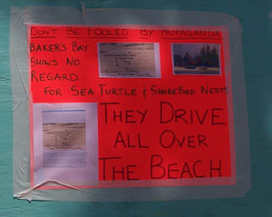
Driving on the beach on Great Guana Cay is illegal. There are many reasons for this, but one reason is particularly important to this story. All seven species of sea turtle in the world are endangered or threatened. Three of those species nest on Great Guana Cay's beaches, and two more less occasionally visit these waters.
For three years, people have been sending me photographs of the four-wheeler and golf cart tracks on both beaches - the three miles of Atlantic beaches and three miles of Sea of Abaco beaches that comprise the outer boundaries of the Bakers Bay megadevelopment.
But now I am seeing it for myself.
Perhaps the primary factor in the decline of green turtles, hawksbill turtles and loggerhead turtles is unsustainable coastal development. Construction activity, water silting, reckless four-wheeler driving - Bakers Bay combs the northern Guana beaches clean of seaweed - another key mistake, if you're concerned about sea turtles.
There are no police on Great Guana Cay. There has never been a need. Before Bakers Bay, there was almost no crime. There is 100% employment. So, when the mainland police get calls from Great Guana Cay residents that Bakers Bay are driving on the beach again, there is really nothing they can, or want, to do. Bakers Bay can do whatever they want.
Since construction began at Bakers Bay, the sea turtle nestings have declined by over ninety percent. This is not surprising. But does six miles of beach in the West Indies matter to the fate of a sea turtle species? When you measure up the remaining undeveloped nesting beaches from the entire West Indies, you realize it's imperitive.
Caribbean nations need to prosper; development is a good thing. But we live in a brave new world, where the old rules of development no longer apply - development in environmental hot-zones must abide by a light footprint and the strictest sustainability plan.
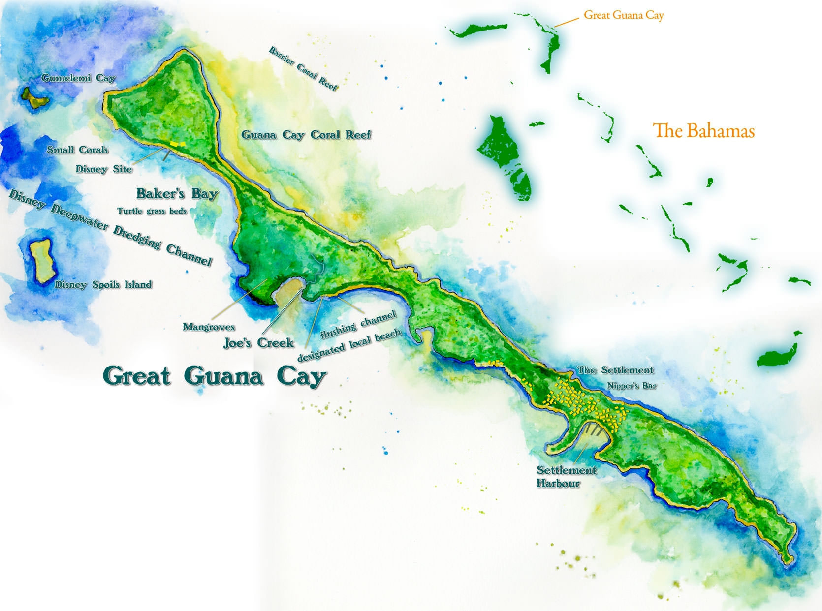
Handpainted map of Great Guana Cay, inlaid with its position in the Bahamas.
In 2006, inspired by the development controversy at Bakers Bay, Jane and I visited a site in Nicaragua that the World Bank was pitching as a golf development. But the owners despised golf, and in deference to a footprint that would have decimated a rich coastal dry forest habitat, they built Nicaragua's most exclusive resort as an eco-resort; a place that adopted ingenuity and restraint to make almost no impression on the land while employing the craft of the local community.
We had been walking on the property with a guide at night. When we approached the beach, the guide wouldn't allow us on the beach. Only one man was allowed on the beach at night; a patrol who was hired to watch, protect and secure the beach for nesting sea turtles. He carried a dim red flashlight that he only turned on when absolutely necessary.
Sustainable development in sensitive areas must abide by these strictest codes.
So why then, even though the international scientific consensus believes Bakers Bay will destroy the nearshore marine environment, is Bakers Bay Club considered by the Bahamian government to be the most environmentally sensitive development ever to grace the shores of the Bahamas?
Wait, did I write that correctly? Bakers Bay is touted as the Bahamas' most sustainable development ever built?
Yes. Correct. But hold on to the guardrail for a moment.
As Jenkins hits the throttle, I see a giant loggerhead turtle emerge from the clear water of Bakers Bay. In this bright light, the animal appears brilliant. What a creature! In a matter of minutes, someone sites a spotted eagle-ray, gliding through the water. Already this morning, I spotted a pair of bottlenose dolphins and a seven foot nurse shark.
As we boat beyond the marina area, we come to the Bakers Bay side beach lots.
"They pack 'em like sardines," Jenkins says, as we stare at the tightly packed lot signs. It is unfathomable that anyone would pay the millions of dollars it costs to purchase these lots. The lots are incredibly small by Abaco standards, and the homes will be built by a single foreign construction company in a matching, Orange County-Arizona country club style superficially adjusted to the yellows, pinks and blues of Bahamian architecture.
On top of that, getting to Great Guana Cay is difficult, especially for the type of high-stress golfers who frequent Discovery Land Company developments. One must fly to Miami or Fort Lauderdale, then take a small flight to Marsh Harbour. A taxi from Marsh Harbour Airport will bring them to a ferry. The oft-packed ferry departs only so many times a day, and takes about forty minutes, and that's all weather-permitting. Travel like that is the antithesis to the idea of the gated-development lifestyle. Folks who want gated communities don't want Cessnas, taxis, customs and ferries packed with sweaty Bahamians. And by agreeing to buy property at Bakers Bay Club, buyers will be committing to living on an island where their very presence is detested.
But the strangest thing about buying into Bakers Bay is the fact that there is a very real possibility that the development will ultimately fail. We have heard that they have already sold 200 lots. But the developer has created an investment culture around its properties; i'ts believed that many of the Bakers Bay lots have been sold by property flippers, who have made hefty profits on Discovery in the past.
Forbes Magazine wrote about the phenomena in June 2005,
"Discovery likes to sell the product before they build it," says Schumacher. "Mike (Meldman, CEO of Discovery Land Company) offers an incentive and makes it economically attractive for people who follow him around by letting them buy lots early on." Discovery doesn't charge property owners membership dues until a golf course is finished...Discovery's customers...often buy multiple lots intending to keep one for themselves while flipping the rest...It helps that these speculators are willing to jump in before much of a development is even built...What can go wrong? Well, if you buy early, you run the risk that a developer might not provide all the amenities promised or that the development goes bust before it's done. Or maybe it's well financed but can't get the building permits it needs..."
Trying to recreate Discovery Land Company luxury in the Abacos seems absurd. The weather is unsuitable to golf much of the year, and small spaces make people stir-crazy. Selling the lots is easy with all of Meldman's dedicated flippers. But what happens when the flippers try to start flipping Bakers Bay?
We throttle along the home lots. "There's the Disney ruins," I say, referring to the thatched building just off the shore. The building was the center of the Bakers Bay property when Disney and Premiere Cruiselines used this land as a cruise ship stopover.
The building was used to house a barbeque and open air picnic seats for guests on Disney's Big Red Boat. After Disney decided to quit using Bakers Bay as a cruise destination, the development was left to shambles. Oil tanks sat in disrepair, the buildings were left to collapse.
Bakers Bay Club used this environmental infraction to its advantage. They pitched themselves as an ecosensitive development that was going to clean up 'Disney's mess.'
Today, it is widely believed that Discovery Land Company is indeed a superior alternative to what came before. But, if we are to put aside the huge dredging operation that created the deepwater channel for cruiselines to get to Bakers Bay, the difference between the two is incomparable.
The Disney spot was a dock, a few buildings, a wooden amphitheatre and a golf cart trail to the Atlantic beach. Bakers Bay Golf & Ocean Club, on the other hand, terraforms 600 acres, a property the size of the Bahamas' most famous island, into one massive urban development - it is the scope, or footprint - the total size of the project that makes it so dangerous. The difference is scale.
The Disney stopover was a product of its times - today, we can view it with 20/20 hindsight with an environmental awareness we lacked then. But the Disney site itself was relatively harmless. Its greatest infraction was its use of exotic plant species. Those exotics never really did much of a number on the Bakers Bay forests. Those forests were tangly, dense, impenetrable; they held up against this wave of exotics.
Jenkins says, "They're using that building as the nursery now."
The nursery is important - it is at the heart of the Bakers Bay marketing game.
The world is going green. We all know that. Sometimes, we feel we are being crammed sustainability down our throat. Sometimes, I want to take that efficient lightbulb and jam it back down the throat of the media barrage. Green has become big business, and companies are finding they can profit handily off the greening of consumers.
I have enjoyed seeing genuine efforts by big business to lessen their carbon footprint, to green their supply-chains, to self-regulate their industries in the absence of appropriate regulation from government. It is all a strange twist to the evolution and refinement of capitalism. We never saw this coming.
But, we also know that in this buzzing world of green, companies have the option to put more money into marketing and product development that makes their product feel green. Or worse, misleads their clients into believing they are protecting the environment by purchasing a product, even though the only changes to the product are the amount of green and brown ink in the packaging.
The greatest defense against greenwashing is intelligent, educated consumers. Usually, if you aren't educated on sustainability issues, maybe you just buy an overpriced toilet cleaner with a picture of a leaf. But greenwashing can be taken all the way, to produce a deception so grand and so vile, you can use it to collapse an entire economy.
Bahamians are, overall, uneducated on the marine issues that matter to them most, and this is a great asset for a golf developer.
Bakers Bay has converted the Disney building into a giant, impressive nursery. Dignitaries from Bahamian government and Caribbean nations are invited to this nursery all the time. A staff of clean-cut, young Bahamians lead them through rows of native plants - Great Guana Cay's dense Bakers Bay interior was the home of several orchid species, and bromeliads; those wicked starry airplants whose bracts blossom in brilliant orange, red and purple displays.
Nothing like this greenhouse nursery has ever existed in the Bahamas.
Isn't it amazing how many resources Bakers Bay is putting into saving the environment?
Sometimes, in conversation on mainland Abaco, you'll hear some Americans talking about how they just came back from a Friends of the Environment meeting. Friends of the Environment is Abaco's environmental group, and Bakers Bay Club gives them sizeable donations each year.
The Americans will say, "I really enjoyed that Friends of the Environment meeting last night. Bakers Bay was there. They are amazing, and sooo nice. Did you know they have a nursery dedicated to saving orchids and bromeliads and all sorts of rare plants?
The press in Abaco help propel the Bakers Bay environmental story. Glowing reviews of their environmental practices often appear in the Abaconian, for example.

The above article had no byline and was likely fabricated.
Actually, though, if you think about it, a nursery has nothing to do with conserving an environmental hot zone.
Here is how it works. Bakers Bay is bulldozing one of the last surviving Bahamas barrier-island forests in existence. Preceeding the bulldozing, units are dispatched to the muddy edge of the construction zone, where they pry the orchids and bromeliads off the about-to-fall tree.
The orchids and bromeliads then get displayed as the centerpiece for Bakers Bay preservation at the nursery. Everything in the nursery looks botanical, and it certainly feels professional.
I talked with one of the botanists hired by Bakers Bay about the species' being collected. This American botanist later quit the project, citing the fact that he was not a biostitute. He explained that the orchids were actually common in the Northern Bahamas. There were no endangered species. If I went into the Bakers Bay property and literally killed each orchid and bromeliad hanging in the trees, I would be committing only a minor environmental injustice.
What's unique about the forests and mangroves of the Bakers Bay area is the habitat itself; and the collection of plants whose habitats are growing increasingly smaller each year. The habitat because of the mixture of the species. Its location. The fact that it is a major stopover for endangered and threatened migrating warblers, sea birds and Abaco endemics. It's importance as a dense forest where few others survive. It's importance as crabbing land and as nursery to the coral reef. Most important, this land is important for its relationship to the coral reef itself.
If you plow it, you destroy the reef.
But we'll get to that later.
During the Christie Administration, Discovery Land Company didn't have to work too hard to make themselves look green. They had the full backing of the government. But as it became clear that the Ingraham administration would be moving in, Discovery Land Company knew what they had to do.
The Bahamas National Trust is a private, self-funded conservation group, which was given authority by the Bahamian government to manage its parks.
Suddenly, the Bahamas National Trust made an announcement.
They announced in the summer of 2007 that they had formed a partnership with the Bakers Bay Golf & Ocean Club. Bakers Bay was offering them a cash gift that would amount to 1.2 million dollars - a gift of such magnitude that the BNT would be able to use it to advance their conservation agenda like never before.
Just one stipulation, though.
According to June 26, 2007 Bahama Journal, "(Bakers Bay) said that after three years Discovery Land Company will negotiate with the Bahamas National Trust, and look at the Trust's accomplishments, performances, objectives and milestones with a view to support the Trust again with a second three-year grant..."
After the grant, The President of the BNT came out in full support of the Bakers Bay Club; "...We are confident that Bakers Bay is doing all the right things that it needs to do to protect the environment. The grant shows that Bakers Bay cares about the environment..."
Bakers Bay staff started appearing at more and more Friends of the Environment meetings.
Around the same time, the University of North Carolina at Chapel Hill announced that it was creating a new campus-wide institute dedicated to environmental research. At the center of the program was an environmental scholarship called the Michael S. Meldman Distinguished Professorship in Conservation, named after the Discovery Land Company president. He allegedly gave 2 million dollars to have the scholarship named after himself. Meldman has no history of environmental donations.
The University of North Carolina at Chapel Hill is home to a marine biology department whose research strongly points to megadevelopment issues as the primary cause for coral reef destruction.
Articles were showing up in the local newspapers; Bakers Bay staff were 'saving sea turtles from locals', who were allegedly digging up turtle eggs for lunch. Everywhere, people were talking about the nursery. I have collected the history of what Bakers Bay employees have said, publicly and privately, about the Guana Cay locals; and it matches the marketing campaigns - make the locals look like animals.
At the same time, Discovery Land Company was working the locals at Great Guana Cay. They created a fund, named after the tree under which the opposition to their development meets. The Fig Tree Foundation would offer the incentive of money to sick locals, to literally offer the hope of life, and to the school, and so on. The Fig Tree Foundation has turned out to be largely a marketing front - most of the efforts the foundation promised to fund were never paid for.
But, who follows up on such things anyways?
There are some genuine green developments in the Bahamas. A good example is Tiamo Resorts in the Southern Bahamas. When magazines write about the best examples of sustainable resorts in the world, Tiamo is often cited. Its footprint is tiny, it's environmental vision is outstanding. And it does so while retaining a level of luxury and quality at the very apex of world tourism.
But while places like Tiamo Resorts create positive publicity for the Bahamas, few people in the Bahamas know much about such resorts, even as they help to balance the constant flow of negative publicity generated by the country's silly advertising campaigns (such as Bahamavention!) and tourist reports of high crime and bad service at megadevelopments in urban Nassau and on Paradise Island.

The environmental qualities of genuine eco-developments like Tiamo versus places like Bakers Bay are not in dispute within the scientific community. The efforts to legitimize Bakers Bay are very similar to the ploys of intelligent design, or astrology. Real scientists don't take that stuff seriously, but pseudo-science proponents have a way of marketing themselves as both legitimate and scientific to the public.
One of the signs that people concerned about development look for when evaluating the early stages of a development is how transparent they are; how much information they are willing to share with the local community and the scientific community about their plans.
As our small boat approaches the northern edge of the property, and towering dunes of golf course sand loom above us, I notice more coral formations in the sea.
This is the spot where, in 2006, a group of scientists decided to do a bit of independent research on what Bakers Bay has been up to under the sea. What they saw was shocking.
The year is 2006. Dr. James Cervino is a coral pathologist and physiologist. He slips on his mask, puts his regulator to his mouth. Along with his assistant from Pace University, and Save Guana Cay Reef President Troy Albury, he descends to the shallow bottom of Bakers Bay.
For several days, the team had been collecting tissue samples from the more robust coral formations enclosed within the barrier reef on the Atlantic side of the Bakers Bay property. Dr. Cervino volunteered to study the potential effect of the Bakers Bay development on the island's coral reef - he is the second of three independent coral scientists to do so.
The team was evaluating an item they learned about in the developer's Environmental Impact Assessment - which we'll call the EIA.
An EIA is a document written about a site that is about to be developed.
Bruce Barcott writes, in a top-selling 2008 environmental thriller whose outcome is directly tied to the Bakers Bay court case:
"In theory, EIA's sound great. In practice, they can be deeply flawed. EIAs aren't intended to be stand-alone gatekeepers. They're reports that make policy makers stop and consider the environmental consequences before approving major projects. As they're evolved - especially in developing countries - EIAs often provide little more than the illusion of environmental checks and balances. Many of the world's largest construction firms now operate lucrative environmental consulting arms that produce slick project-justifying EIAs for the worst sorts of developments."

which they renamed Castaway Cay, in the Sea of Abaco.
In reality, nobody ever reads EIA's. The Bakers Bay EIA is particularly large. Likely, the authors probably thought nobody would ever read this monster either. It goes on and on about - you guessed it - native plants.
Little did they know at the time, the Bakers Bay EIA would be picked over for years.
But in the huge document, where was the section on the marine environment?
The lead designer of the EIA is an American named Kathleen. She is a marine biologist. Why did the EIA contain little about the marine environment? When people think of Guana Cay, they think coral reef. When people think of the Bakers Bay end of Guana Cay, they think, magnificent coral reef! How could a marine biologist forget to include sufficient mention of the coral reef and nearshore marine environment in general?
That is a question that has plagued opponents of Bakers Bay for years. Now, it is March 2008, and I am in a small boat heading north along the Bakers Bay property. We look up at the towering mounds of artificial sand dunes - we have arrived at the monstrous golf course development site, which is being masterminded by Tom Fazio. I asked a golfing friend what he thought about Tom Fazio courses.
"I've golfed a lot of the Fazio courses. You know, the problem with that guy is he likes to move a lot of fucking dirt."
I had said, "I heard serious golfers don't like Tom Fazio courses - he designs the courses so the balls suggest themselves toward the hole?"
"Exactly!"
And that masterminded, sculpted, dirt-moving look is part of the very story of this coral reef's likely doom. The sand dunes can be seen from ten miles away.
"You know," says Jenkins, "Kathleen isn't even coming to Bakers Bay every month anymore."
I say, "What's shocking about that statement is the fact that she is supposed to come only once a month in the first place." It's easy to get the impression that a full time biology staff is monitoring the Bakers Bay construction project - but it's an illusion, especially if Kathleen isn't even visiting the site anymore.
Kathleen isn't only the lead designer behind the EIA. She is also the head of the Environmental Monitoring Team - the official crew designated by Discovery Land Company to study, report on and give grades to the developer to make sure they are living up to their environmental promises. Also, her team is in charge of communication with the local community, and to facilitate the reporting of incidents.
But nobody seems able to report incidents, and the supposed report cards do not exist. To have the biologist who wrote the EIA also act as the head of the monitoring crew is also suspect - but then Kathleen comes from the BEST Commission anyways - the organization responsible for approving developments in the Bahamas.
While she is set up to appear independent of the development, her counterpart, a Bahamian named Livingstone Marshall, is the official environmental chief at Bakers Bay Club. He also comes from the BEST Commission - he was hired away from his position as the Prime Minister's environmental consultant.
Back on that sunny day in 2006, at the bottom of Bakers Bay, Cervino found a handful of large concrete blocks covered in algae.
A small section of the EIA had led the scientists here. Although little was mentioned about the reef in the EIA, there was a tiny section that explained that artificial reefs could be used to restore and repair reefs damaged by development.
Artificial reefs are often failures, and no sane conservationist would ever consider an artificial reef to prop up a healthy reef - they are last resorts for reefs already nearly dead. Furthermore, the immense size of the Guana Cay reef would make artificial reefs an impossibility for mitigation anyways.
And what the scientists found made perfect sense. The artificial reefs were covered in algae...they were a complete failure, indicating that the entire published plan for protecting the coral reef would be a failure.
The animals that secrete a stony exoskeleton and create the building blocks of the coral structure are called polyps. They are incredibly beautiful animals in miniature, like tiny anenomes; fragile little monsters belying the mountains they build. There are thousands of coral species, each with unique attributes designed to survive in unique habitats, or to fill unique roles in complex reef habitats.
Dr. Cervino's expertise is unique in the coral world - he diagnoses diseases in polyps, and has a fondness for their internal structure. The specialized nature of his research is evidence of a science that is coming into its own; Cervino's research stands on the shoulders of other, more general research that is with each month, more conclusively unraveling the mysteries of the coral world.
Over the past 50 years, but especially so in the 1980s, 1990's and today, coral reefs have been dying. By the year 2030, scientists predict that only fifty percent of the world's coral reefs will remain. This possibility will represent one of the most devastating and singularly abhorrent events ever committed by humanity. With this destruction will be widespread loss to our economies, to biological diversity and to the Earth itself - coral reefs are crucial to the regulation of the Earth's atmosphere.
Because of the widespread deaths of coral reefs around the world, most nations have implemented strong protection for them. But, just as the Bahamas denies sea turtles vital protection where others have long ago joined the international community, the Bahamas has no genuine laws to protect its coral reefs.
What is responsible for the death of coral reefs? - overfishing, invasive species, climate-change induced bleaching and so forth. There are even reports of chipped boat paint and sunscreen contributing to coral deaths. But one umbrella issue stands above the rest for nearshore corals, particularly in the Caribbean.
Corals die from nutrient overload.
This is the irony and beauty of the coral story. Most dense, species-rich ecosystems rely on an abundance of nutrients to thrive. Coral reefs can survive only in nutrient-poor water. Scientists have even determined the maximum nutrient threshold in which corals can survive.
Although in the South Pacific and Indian Ocean, many corals live in shallow water far from any land, and exist in nearly zero nutrient conditions. But corals in the Bahamas and Caribbean thrive in shallow water near land, and their existence depends on the way the land filters the nutrients. In the Bahamas, mangrove communities act as filters between the nutrients of the land and the sea.
If you remove a mangrove from a shore near a reef, you remove the filter.
Every coastal coral reef contains small amounts of algae and phytoplankton growing here and there. When a sustained unnatural act creates an influx of nutrients, the plants respond in kind, quickly growing and smothering the coral structures, suffocating the coral polyps.
The death of the coral polyps creates a chain reaction because all the other creatures of the reef rely on the corals being alive. Just as a forest is no longer a forest if the trees are dead.
All three coral scientists who have visited the Bakers Bay site, each acting independently from the other, has pronounced the Bakers Bay project a disaster for the island's coral reef.
There isn't any if's or but's about it.
There isn't anything the developer can do to avoid it unless they drastically change their development plan.
There isn't any question in the coral scientific community. A consensus of relevant scientists back the position of the visiting coral scientists (and therefore of Save Guana Cay Reef.) Although hundreds of coral scientists and marine conservationists have commented and contributed to the Bakers Bay discussion, not a single one has taken the position of Discovery Land Company and its hired biologists.
So, why?
First, building the marina by gutting the island's mangroves removes the filter between the reef and the land - creating a near instant and permanent nutrient load directly into the reef. Then, by creating ten years of construction activities, which includes oil spills, clear-cutting, silt-creation and more, Bakers Bay is adding layers of nutrient loads into the reef. Already, these are death sentences for the reef.
But it's not over yet, because four elements in the completed Bakers Bay project plan also spell death to the reef: the existence of the marina, the massive alteration of the landscape, the dense housing and subsequent sewage issues, and, above all else, the golf course itself.
Great Guana Cay is a limestone island. If you pour a glass of water onto an exposed piece of the island's bedrock on a dry day, the water will stick around for a few seconds, and then disappear.
The water hasn't found a crack to drain down. It has, in fact, seaped into the rock itself. The Great Guana Cay limestone is porous; the cay being created by corals from ages ago. In a few weeks, the water from our cup will seap into the coral reef itself.
For thousands of years, the reef worked with the cay; it developed and grew according to the shapes and nutrient output of the island. A few hundred years ago, human settlement appeared on the island, and therefore, a small change to the nutrient output of the island appeared. But this human settlement was built around a natural harbor which slanted into the Sea of Abaco, opposite the reef on the Atlantic, several miles south of the main reef structures anyways.
So, what motivates a biologist to support a development like Bakers Bay? Again, Barcott offers a possible explanation in Last Flight of the Scarlet Macaw:
"The trick was to find biologists willing to sign off on an EIA that gave the all-clear. In the United States, that's not a problem. As the tobacco companies can tell you, plenty of scientists are happy to sell their scruples to the highest bidder. Environmentalists often deride these pliable researchers as biostitutes.' If biostitutes can be found, an EIA consultant can subcontract the scientific studies to reputable researchers and then hide of misrepresent their findings. Often this is done through summary fraud, in which dire findings in the scientific data are ignored or contradicted in the report's executive summary. The deception usually works because most researchers sign nondisclosure agreements that prevent them from talking to the press."
Another hint is offered in the EIA itself- in exchange for her support, Kathleen gets, literally, her own real life lab to experiment on- if the island collapses, the EIA suggests, Kathleen's research benefits.
The EIA says,
"The project will be an experiment in sustainability for small island developments. Clearly, local residents or Bahamians in general would not appreciate being the site of “experimental" approaches to development of their natural resources, but the aim of the experiment is to provide a truthful documentation of the real ecological costs.
While the developer has millions to contribute to research, monitoring and to the myriad donations to the institutions that may oppose them, the local's scientific efforts are limited to the hope that a scientist will yet again volunteer the expenses of his plane tickets, his laboratory costs, his vacation time, and the cost of his staff's time.
But a strange twist in this story will begin today, as we strike up a conversation - what if the world's most relevant scientific team visits the Bakers Bay property?
In the absence of any meaningful data from Kathleen or the developer, what if the coral dream team could offer numbers and analysis, for the world to see?
In May 2008, Great Guana Cay will make good on this conversation - frantically, they will begin organizing a potluck. Yes, potlucks and t-shirts - the local's only funding source. They have one month to come up with the funds necessary to fly a new team to Great Guana Cay.
While they scramble for a donation here, a donation there to build their scientific case, a charismatic young lawyer coolly builds his case for court.
I sit in the passenger seat with Jenkins as he drives his golf cart down a narrow street of Guana Cay’s settlement.
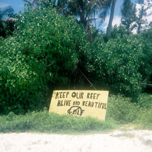
I ask him where all the Save Guana Cay Reef signs are. For the past three years, the signs have decorated the settlement. They say things like, ‘Keep our reef alive and beautiful’ and ‘Respect the Locals’ They are hand-painted signs on plywood.
Jenkins gives me this look, the kind a farmer might give a city boy asking for directions. He says that the signs disappear in the night. “We find them at the bottom of the harbor,” he says, pointing to the natural moon-shaped harbor. “We find them in the woods.”
“Just a few days ago, they threw them in our cemetery. That’s vandalism and desecration,” Jenkins says as we pass the island’s small cemetery. I ask, “Why don’t you just make more signs?”
“It’s not that easy,” Jenkins explains. “Those plywood sheets are not cheap. We can’t afford to always make new signs.”
He says, “paint costs money.”


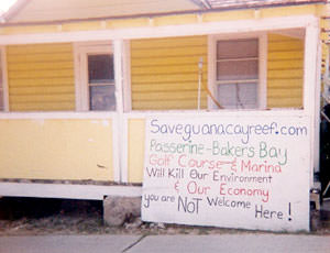

This comment gives me pause; Save Guana Cay Reef hasn’t two hundred bucks for a big sign. No money, no voice, like so many other small faraway places, doomed by isolation.
Discovery Land Company on the otherhand, has unleashed millions against Save Guana Cay Reef. Their international legal team resembles O.J. Simpson's in its size. They have poured millions into image control in the form of donations to local environmental groups, to Universities, even in the form of promises of money to locals of Guana Cay itself.
Jenkins drops me off near the Nippers bar. I have a few hours to kill, and I want to soak in as much about Great Guana Cay's settlement as possible. I’ll be writing about this place for the next several years. I decide to explore Guana with my binoculars on foot. The late afternoon sun shines sweetly on the old loyalist homes, tempered by the shadows cast by tree leaves.
I start walking downhill from Nippers, cross a few streets, then walk uphill again. I see an off-road golf cart coming down the hill. It is occupied by two very large men, so large they make the cart look like a rickety thing from the Flintstones. The driver is smoking a large cigar. He is drunk. He says, “You going that way?” pointing to the direction I am going. I tell him I am. He says, “you gonna have a lot of trouble getting up that hill.” I say I didn’t think it would cause me any trouble. He laughs at this and starts saying all sorts of drunk things I can’t understand.
And, this is always a great way to get rid of drunks: I walk up to him and give my high-five hand. I say, “yeah!” And then I slap his hand. I say, “rock on, man!” really loud.
He belts out a sort of woohoo, and then kicks his golf cart back in motion, which causes the fat passenger to lurch forward. I turn around and realize that I’m looking at a Baker’s Bay Club golf cart.
I go down to the harbor, and walk out into it at low tide and watch a little blue heron wading. Little blue herons are brighter, sleeker animals than their great blue relatives, and the way they run along the shallows after a fish can be dazzling.
Great Guana Cay was where I first began identifying animals as a sort of game. Unlike most North Americans, I started with fish instead of birds. I learned my grunts, my angelfish, my soldierfish, my rays and skates. I kept tabs of the fish I had seen in the wild.

I even began learning my reef invertebrates, my corals, and my sea mammals on the reef of Great Guana Cay. The act of collecting species' names is a joy shared by millions, but the process of doing so, all those years ago, has now made me equipped to write about Great Guana Cay - small places are rarely so rich in such a diversity of species. Because of Great Guana Cay's position as a bulwark between the Caribbean and the Atlantic, because of its unique shape and its unique protected reef, it has always been a magnet for diversity. Today, I want to get an idea of the land diversity of the island.
From the harbor, I walk without direction - across to the Atlantic beach, then on a narrow path where I notice an even narrower path. I find myself inside a part of Great Guana Cay's settlement I never knew existed - a secret series of gardens: tomatoes, peppers, bananas, citrus, coconuts, squashes. I have no idea if I'm on private property, or if these are some sort of public gardens - but the gardens are rich in bird life. Bananaquits, West Indian woodpeckers, Cuban emerald hummingbirds.
I slowly make my way to Docksiders Restaurant, where members of Save Guana Cay Reef wait to tell me their story, and what's going to happen next.
This series continues with Wings to the Storm.