Mangrove Conservation
April 22, 2009
From Mangroves to "Disney Main Street"

Abaconians and other residents of the Northern Bahamas are beginning to question the Bakers Bay Club from a cultural perspective, as members of Save Guana Cay Reef have since the beginning.
This image from November 2008 shows the marina village, which is built on a terraformed landscape which was formerly the island's last remaining mangrove habitat.
Locals and visitors, seeing the construction for themselves, are beginning to say,That doesn't look Bahamianand It look's likeDisney's Main Street. AndI had no idea it was going to be so tightly packed together.
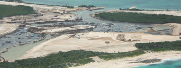
The Marina site in 2007. The marina is dangerously close to the coral reef. Since the island is made of porous limestone, the nutrient overloads and pollutants seep directly into the reef - the classic combination of toxic death for coral reefs.

In 2008, I photographed massive silting from the construction site. In addition to the nutrient overload caused by this development, this silting kills corals.
August 5, 2008
Mangrove Loss and Climate Change—A Global Perspective - Article from World Rainforest Report mentions Great Guana Cay

Guana Cay mangroves under threat
Mangroves are the rainforests by the sea. Large stretches of the sub-tropical and tropical coastlines of Asia, Africa, Oceania, the Americas and the Caribbean are fringed by mangroves, once estimated to cover an area of over 32 million hectares.
Now, less than 15 million hectares remain —less than half the original area.The importance of the protective mangrove buffer zone cannot be overstated.
In regions where these coastal fringe forests have been cleared, tremendous problems of erosion and siltation have arisen, and terrible losses to human life and property have occurred due to destructive hurricanes, storm surges and tsunamis.Today there is a growing urgency to recognize the importance of conserving and restoring protective mangrove greenbelts to lessen the dangers from future catastrophes, because as sea levels rise so will the frequency and intensity of hurricanes and storm surges.
Mangroves can buffer against the fury of such destructive storms, protecting those settlements located behind a healthy mangrove fringe.Mangrove Action Project (MAP)is working with other organizations in the global South towards restoring degraded and cleared mangrove areas as a high priority. MAP is especially interested in restoring some of the 250,000 ha of abandoned shrimp farms located in former coastal wetland areas, especially in Asia and Latin America.
But, even more importantly, MAP is working to help conserve and protect existing mangrove wetlands around the world.Conserving existing mangroves and restoring the vast areas of degraded and cleared mangrove wetlands will serve as a partial solution to global warming. Our planet perhaps faces one of the greatest threats to life as we know it.
This crisis is being fueled by human induced climate change. Because nearly half of humankind today lives in cities and settlements located along the now vulnerable coasts, global warming and consequent sea level rise cannot be ignored. Already evacuations of low-lying islands have begun in South Asia and the South Pacific Islands.
It is expected mass evacuations of millions of coastal residents will occur within the next 50 years as sea level continues to rise as a result of the greenhouse effect caused by excessive carbon gas emissions.Nevertheless, mangrove wetlands are often the first line of defense, helping to secure the coasts against erosion and storms.
Mangroves are also one of nature's best ways for combating global warming because of their high capacity for sequestering carbon. This is a characteristic of mangrove wetlands that now demands our most immediate and undivided attention.
One of the greatest contributions that mangroves may have to offer is their great propensity to sequester carbon from the atmosphere and store this in their wetland substrate. According to the Feb.
2007 issue of National Geographic, "Mangroves are carbon factories… Measurements suggest that mangroves may have the highest net productivity of carbon of any natural ecosystem (about a hundred pounds per acre per day)…"Mangroves have been seriously undervalued by those government agencies responsible for their protection and management, as is so clearly evidenced in the Caribbean, especially in the Bahamas where such travesties in shortsighted developments are now occurring at Guana Cay and Bimini Islands.This combined lack of conservation ethic, shortsighted greed and weak law enforcement have allowed massive losses of these coastal wetlands, with one huge, hidden cost arising from the oxidation and release of stored mangrove carbon.From a study performed by Dr.
Ong of Universiti Sams in Malaysia, it was found that the layers of soil and peat composing the mangrove substrate have a high carbon content of 10% or more.. Each hectare of mangrove sediment might contain nearly 700 metric tons of carbon per meter depth.
In building large numbers of shrimp farms or tourist complexes, the resultant clearing of mangroves and subsequent excavation of the mangrove substrate could result in the potential oxidation of 1,400 tons of carbon per hectare per year.
Again, according to Dr. Ong, "Assuming that only half of this will become oxidized over a period of 10 years, we are looking at the return of 70 tons of carbon per hectare per year for ten years to the atmosphere. This is some 50 times the sequestration rate.
This means that by converting a mere 2 percent of mangroves, all of the advantages of mangroves as a sink of atmospheric carbon will be lost…"According to the latest study by the UN's Food and Agriculture Organization (FAO), the current rate of mangrove loss is around 1% per annum—or around 150,000 ha of new mangrove area loss per year.
This translates to around 225,000 tons of carbon sequestration potential lost each year, with an additional release of approximately 11 million tons of carbon from disturbed mangrove soils each year.Obviously, this is an immense problem requiring our concerted action.
Not only are we losing the important potential for carbon sequestration offered by the mangroves, but we are also seeing the release of major quantities of polluting gases from the disturbed mangrove substrate itself.
This continued clearing of mangroves for whatever reasons must now be perceived in an entirely new light…a light that illuminates far beyond the dark crevices of development for convenience and profit to a future for life and a sustainable living on this now endangered planet…this home we call our Earth.By Alfredo Quarto, Executive Director, Mangrove Action Project
July 24, 2008
Nature Magazine on Mangroves

The mangroves of Great Guana Cay have been removed to build a marina.
Nature Magazine discusses the value of coastal mangroves to fishing. Those who have been decrying the destruction of mangroves at Bakers Bay have been saying the same thing for four years now - that the Bakers Bay Club's destruction of Great Guana Cay's mangrove fisheries will lead to a decline in fish populations, upsetting both reef tourism on the reef and fishing near Bakers Bay.
The authors write,This economic value reinforces the need for governments to preserve mangroves, the researchers say. "Without a coastal mangrove ecosystem, the cost of food can only increase," says Aburto-Oropeza.
Nature Magazine Article on Mangroves
07.06.07
Updates in Photographs|The silt curtains are ineffective. This image shows silt on either side of the curtain. Constant silt in pristine marine areas can destroy the marine environment. Silt is particularly harmful to corals.Save Guana Cay Reef advertises their struggle on signs which are displayed on private property.Bakers Bay Club doesn't like the signs. Often, potential buyers will ask what the signs are about. When Bakers Bay Club employees try to change the subject, often the potential clients will try to find out themselves. Some of these clients become advocates for saving the island from the Bakers Bay Club.This is an image from the height of sea turtle nesting season. Bakers Bay employees rake the oceanside beaches near the northeastern tip of the island on a regular basis, even at the very height of sea turtle season.
|
The silt curtains are ineffective. This image shows silt on either side of the curtain. Constant silt in pristine marine areas can destroy the marine environment. Silt is particularly harmful to corals.

Save Guana Cay Reef advertises their struggle on signs which are displayed on private property.

Bakers Bay Club doesn't like the signs. Often, potential buyers will ask what the signs are about. When Bakers Bay Club employees try to change the subject, often the potential clients will try to find out themselves. Some of these clients become advocates for saving the island from the Bakers Bay Club.

This is an image from the height of sea turtle nesting season. Bakers Bay employees rake the oceanside beaches near the northeastern tip of the island on a regular basis, even at the very height of sea turtle season.

07.04.07
Crabbing Grounds Are Now Gone Forever

The location of the crabbing grounds is now completely destroyed.According to locals on the island of Great Guana Cay, the island's crabbing grounds have been lost to the Bakers Bay Club.
For over 200 years, the people of Great Guana Cay relied on this area for subsistence.It is ironic that in Kathleen Sullivan-Sealey's research for the Bakers Bay Club and the University of Miami, her team writes, "Conservation techniques employed to control cat populations on islands have been successful in preventing extinctions and restoring ecosystems in the past decade...In order to prevent further negative impacts on bird, reptile, and land crab populations on Great Guana Cay, control and eventual eradication of feral or stray cats is suggested."Sealey's recommendations on feral cats is laughable, especially since the crabbing grounds have been lost, not to cats but to the bulldozer that paid for her research.Eliminating feral cats from sensitive areas is of course a good practice in environmentally sensitive areas; but if the crabs the programs are trying to save are lost, what is the point?
Interestingly, the U of Miami report explains that feral cats didn't really exist on the Bakers Bay property until development began. From a common sense perspective, I would agree with this.
The terrain on that end of the island was hardly suitable for travel by cats.Here is a quote from Sealey's plans for Great Guana Cay cats:"Plan for Controlling Cat Populations on Great Guana Cay:Our goal is to eradicate feral cats on the island, and continue trapping to monitor the introduction of new cats.
The use of 15 cage traps has been approved by Mr. Pinder, Director of The Bahamas Ministry of Agriculture. These traps will be loaned by Mr.
David Knowles, and will be placed at various locations around the Baker's Bay Club property. The traps will be baited with fish and catnip, and checked daily. Hand-capturing will also be attempted. Dr.
Derek Bailey, a veterinarian based in Marsh Harbour, will be assisting with cat disease testing, sterilization, andeuthanasia."
According to locals on the island of Great Guana Cay, the island's crabbing grounds have been lost to the Bakers Bay Club. For over 200 years, the people of Great Guana Cay relied on this area for subsistence.

It is ironic that in Kathleen Sullivan-Sealey's research for the Bakers Bay Club and the University of Miami, her team writes, "Conservation techniques employed to control cat populations on islands have been successful in preventing extinctions and restoring ecosystems in the past decade...In order to prevent further negative impacts on bird, reptile, and land crab populations on Great Guana Cay, control and eventual eradication of feral or stray cats is suggested."
Sealey's recommendations on feral cats is laughable, especially since the crabbing grounds have been lost, not to cats but to the bulldozer that paid for her research.Eliminating feral cats from sensitive areas is of course a good practice in environmentally sensitive areas; but if the crabs the programs are trying to save are lost, what is the point?
Interestingly, the U of Miami report explains that feral cats didn't really exist on the Bakers Bay property until development began. From a common sense perspective, I would agree with this. The terrain on that end of the island was hardly suitable for travel by cats.Here is a quote from Sealey's plans for Great Guana Cay cats:
"Plan for Controlling Cat Populations on Great Guana Cay:Our goal is to eradicate feral cats on the island, and continue trapping to monitor the introduction of new cats. The use of 15 cage traps has been approved by Mr. Pinder, Director of The Bahamas Ministry of Agriculture. These traps will be loaned by Mr.
David Knowles, and will be placed at various locations around the Baker's Bay Club property. The traps will be baited with fish and catnip, and checked daily. Hand-capturing will also be attempted. Dr. Derek Bailey, a veterinarian based in Marsh Harbour, will be assisting with cat disease testing, sterilization, andeuthanasia."
06.27.07
Discovery Land Company Falsely Advertises their Unsustainable Marina is a Blue Flag Marina
"Baker's Bay Golf and Ocean Club, located on the northern end of Great Guana Cay in the Abacos will comprise an exquisite residential community of 585 stunning beachfront and ocean view acres, 175 custom home sites and183 high-end single-family developer residences.
The development will also include a villa-style hotel, private golf club, 18-hole Tom Fazio-designed private golf course and a 33-acre marina village with a 158-slip "Blue Flag" marina."- From Bakers Bay Club Press Release

The Bakers Bay Club released a press release stating that its marina had been awarded the Blue Flag designation. This is one of several false statements in which Bakers Bay Club has attached itself to the authority of the Blue Flag group. But Bakers Bay Club has indeed not been awarded Blue Flag designation.You can read more about Blue Flaghere.
The Blue Flag group does consider wider environmental implications in its assessment.
July 22, 2006
The Orchid Hothouse of Death
Discovery Land Company, the developer of the Bakers Bay Club has been advertising its greenhouse.
The greenhouse is being used to 'save' orchids and other plants from when the developer bulldozes one of the most important ecological zones in the Bahamas.The Bahamian press, which is uneducated on environmental matters, equated the saving of orchids to a green developer.
Bakers Bay Club is bulldozing acres of a unique terrestrial ecosystem, one that the EIA for the development admits is a vanishing ecosystem.
Orchids beware. Bahamian press are wooed by the Bakers bay Club greenhouse, which is a red herring for genuine ecological issues regarding the development.
photo courtesy SGCR.The botanical collections at Bakers Bay Club clearly sidesteps the primary environmental issues, and appears to be used as a red herring to divert genuine concerns about the coral reef and mangroves of the island. Bakers Bay Club has collected some orchids and preserved them in a greenhouse, wooing many in the media into thinking they are careful land stewards.That a few orchids were spared the bulldozer scarcely compensates for the inevitable alteration of Great Guana Cay's ecosystem during the massive terraforming and dredging that would accompany the construction of their golf course, marina, residential units and service facilities. The orchids, incidentally, are not endemic to Great Guana Cay, although the public relations campaigns at Bakers Bay Club make it appear they are.According to Keith Bradley, a former botanist at the Bakers Bay Club, the orchid's Bakers Bay Club are 'saving' are actually quite common in the Bahamas.Bradley writes, "There are a number of common species and these are the ones on Guana.
These are Encyclia boothiana, Encyclia rufa, Cattleyopsis lindenii, and Oncidium floridanum. There is also a common species that may or may not be native, Oeceoclades maculata. There is one species which I have indicated as rare and needing special protection, Tolumnia (Oncidium) sasseri. It is known otherwise only from Abaco and Andros.
In truth though, taxonomists who have studied this genus carefully don't think it is a good species, instead being the more common Tolumnia (Oncidium) bahamensis. I would tend to agree."

Orchids beware. Bahamian press are wooed by the Bakers bay Club greenhouse, which is a red herring for genuine ecological issues regarding the development. photo courtesy SGCR.The botanical collections at Bakers Bay Club clearly sidesteps the primary environmental issues, and appears to be used as a red herring to divert genuine concerns about the coral reef and mangroves of the island. Bakers Bay Club has collected some orchids and preserved them in a greenhouse, wooing many in the media into thinking they are careful land stewards.That a few orchids were spared the bulldozer scarcely compensates for the inevitable alteration of Great Guana Cay's ecosystem during the massive terraforming and dredging that would accompany the construction of their golf course, marina, residential units and service facilities. The orchids, incidentally, are not endemic to Great Guana Cay, although the public relations campaigns at Bakers Bay Club make it appear they are.According to Keith Bradley, a former botanist at the Bakers Bay Club, the orchid's Bakers Bay Club are 'saving' are actually quite common in the Bahamas.
The botanical collections at Bakers Bay Club clearly sidesteps the primary environmental issues, and appears to be used as a red herring to divert genuine concerns about the coral reef and mangroves of the island. Bakers Bay Club has collected some orchids and preserved them in a greenhouse, wooing many in the media into thinking they are careful land stewards.That a few orchids were spared the bulldozer scarcely compensates for the inevitable alteration of Great Guana Cay's ecosystem during the massive terraforming and dredging that would accompany the construction of their golf course, marina, residential units and service facilities. The orchids, incidentally, are not endemic to Great Guana Cay, although the public relations campaigns at Bakers Bay Club make it appear they are.October 27, 2005
Of Marinas and Mangroves
"Contrary to prevalent rumors, Joe's Creek, the mangroves and the Guana Cay bonefish flats will all be preserved and not altered by development."- Advertisement from Discovery Land Company's Bakers Bay Golf and Ocean ClubWritten on October 27, 2005.Below the star-speckled surface, greenish orbs by the thousands pulse in sync. Grand cathedrals of roots rise from this metropolis of the weird. Its woody columns are inlaid in horned shells that move slow, like a golf cart in search of a lost ball. Fishes of many forms pass beneath these spires. As your keen eye wanders upward these spires, you will perhaps find an ivory butterfly form - an encyclia orchid - dangling like an angel, and even higher a green bird with a painted face - a green heron, whose wading demeanor is almost regal.But all of these things, you will find only in a very subtle context. For this place, draped in layers of green, is so subtle a place that for most of history it was considered the dredges of the world.This place, this lovely place is an Abaco mangrove.Mangroves constitute most of the Bahamian Abaco Islands. Fly over in a plane, most of the island is mostly submerged at high tide.The mangroves so dominate Abaco's "land" that the island has produced a fair trade out of a type of rugged tourism called bonefishing - saltwater flyfishing concentrating on the slim and transparent fish who meander these flats.A mangrove is a community of salt-tolerant plants and trees that live in the muddy tidal flats of our world's tropical regions. These are a complex ecological buffer zone that serve to stabilize the land as well as feed the sea the bounties of the land. Equally, the mangroves act as the nursery of the sea. Sharks bear their young here. Coral reef fishes begin their awkward lives between the roots of giant mangrove trees. Molluscs grow.The mangrove is part of a complex triangular relationship with the seagrass community and the coral reef.Perhaps most important, the mangroves absorb excess nutrients before they make it to the nearshore environment. For many of these environments, foremost among them the coral reef, this aborption helps buffer them against their killer - excess nutrients.The small islet of Great Guana Cay features its own mangrove systems. The southern mangrove system has recently been ripped out by a developer on the southern end of the island, which leaves only the larger mangrove system on the northern end of the island.Enter the Discovery Land Company and their Bakers Bay Golf and Ocean Club.Here on the northern end of the island, the Discovery Land Company is going to rip out a gigantic swath of the last mangrove system on the island, and dredge out a gigantic marina - 180 slips. According to the Discovery Land Company's own website, some slips will be for sea-cruisers up to 200 feet long.The consequences of this marina are far-reaching for the conch-fishing grounds, the bonefishers, the coral reef, the island's bird foraging habitat and the terrestrial ecosystem itself. Once the mangrove goes, so will the island's ecology. So how is it possible that the developer has said, "Contrary to prevalent rumors...the mangroves...will all be preserved and not altered by development."Photo courtesyLory Kenyon.
A view of Joe's Creek, the bonefish flats and the mangrovesPerhaps what they mean is that they will save trees of one of the mangrove species. A little tricky language can take you a long way.
But a mangrove is a community, and the developer's plans entail ripping out the mangrove system seen in the photograph above.At the center of this strange debate stands a battered marine ecologist who leads the paid consultant team of the Bakers Bay Golf and Ocean Club, and has created an EIA that more or less 'forgets' some of the most important aspects of impact. This 'sugar-coating on a poison pill' has been lambasted as an illogical document. Instead of examining the important components of marina flush-rates and gray water, the EIA largely concentrates on second-level environmental issues like litter (which the developer will clean up!) and orchid-thieves (which the development will stop!)But government's rarely read EIA's anyways. And Prime Minister Christie sees international outrage over his support of such projects as the Bakers Bay Marina and the Bimini Golf Course as simply a tiresome obstacle to overcome. He has no inclination that perhaps the science community of the world is...correct.The marina will require ripping out the island's last mangroves and poisoning the island's flyfishing and bonefishing flats, as well as contributing to threatening the very ecosystem the islanders depend on for their livings. The marina will help to poison a fragile coral reef, one of the last intact in the world.Dr.
Michael Risk writes, "Throughout the EIA, mention is made of legislative guidelines and policies in place in the State of Florida. This seems in keeping with the attitude taken by many foreigners coming to Bahamas, that it is not a sovereign nation but an extension of Florida. In this, and in all developments, it is necessary to compare what is proposed with what is actually done.
If Florida has such effective laws and guidelines, then the environmental situation in that State should act as a model for all similar jurisdictions. It is instructive indeed to compare the proposed situation in Florida with what really happens.
If similar developments in Florida have had deleterious effects, despite those laws, then it might be expected that the same thing would happen on Guana, no matter what paper guidelines were in place. The best comparison would be with the Florida Keys, because of their geomorphic similarity to Bahamas."Photo Courtesy Lory KenyonIn a telephone interview, Dr.
Risk explains that the Guana Cay marina, as a percentage of total area on the island compared to marinas in Florida or the Florida Keys, is compounded to such a high level, that one can only rationally assume the worst.In his response to the developer's EIA, he writes, "Marinas in the Keys, despite EPA regulations on flushing rates, are generally biological dead zones, with fuel spills, toxic chemicals, and anoxic sediments.
In addition, virtually all of the virulent human viral and bacterial pathogens may be found in the waters of marinas in the Keys: Hepatitis A&B, cholera, tetanus, the lot..."Kathleen Sullivan Sealey, paid consultant to the developer, told me in an email interview that, "Bakers Bay Club will be the first Blue Flag Marina in the Bahamas...look up the criteria forthis programme out of the European Union Global Environmental Programme website."Actually, a Guana Cay homeowner did contact the program.
A representative of the blue flag program writes her, "In the International Blue Flag Coordination we are not aware of a planned marina in Guana Cay wishing to apply for Blue Flag status. I will therefore ask the Caribbean and Bahamian Blue Flag co-ordinators to investigate the issue and return to me with a reply.
I will keep you informed."Then Discovery Land Company's consultant says, "then you should ask the Bahamian owners of Boat Harbour or marinas in Marsh Harbour why they are not striving for the same standards?"
Written on October 27, 2005.Below the star-speckled surface, greenish orbs by the thousands pulse in sync. Grand cathedrals of roots rise from this metropolis of the weird. Its woody columns are inlaid in horned shells that move slow, like a golf cart in search of a lost ball. Fishes of many forms pass beneath these spires. As your keen eye wanders upward these spires, you will perhaps find an ivory butterfly form - an encyclia orchid - dangling like an angel, and even higher a green bird with a painted face - a green heron, whose wading demeanor is almost regal.
But all of these things, you will find only in a very subtle context. For this place, draped in layers of green, is so subtle a place that for most of history it was considered the dredges of the world.
This place, this lovely place is an Abaco mangrove.
Mangroves constitute most of the Bahamian Abaco Islands. Fly over in a plane, most of the island is mostly submerged at high tide.
The mangroves so dominate Abaco's "land" that the island has produced a fair trade out of a type of rugged tourism called bonefishing - saltwater flyfishing concentrating on the slim and transparent fish who meander these flats.
A mangrove is a community of salt-tolerant plants and trees that live in the muddy tidal flats of our world's tropical regions. These are a complex ecological buffer zone that serve to stabilize the land as well as feed the sea the bounties of the land. Equally, the mangroves act as the nursery of the sea. Sharks bear their young here. Coral reef fishes begin their awkward lives between the roots of giant mangrove trees. Molluscs grow.
The mangrove is part of a complex triangular relationship with the seagrass community and the coral reef.
Perhaps most important, the mangroves absorb excess nutrients before they make it to the nearshore environment. For many of these environments, foremost among them the coral reef, this aborption helps buffer them against their killer - excess nutrients.
The small islet of Great Guana Cay features its own mangrove systems. The southern mangrove system has recently been ripped out by a developer on the southern end of the island, which leaves only the larger mangrove system on the northern end of the island.
Enter the Discovery Land Company and their Bakers Bay Golf and Ocean Club.Here on the northern end of the island, the Discovery Land Company is going to rip out a gigantic swath of the last mangrove system on the island, and dredge out a gigantic marina - 180 slips. According to the Discovery Land Company's own website, some slips will be for sea-cruisers up to 200 feet long.
The consequences of this marina are far-reaching for the conch-fishing grounds, the bonefishers, the coral reef, the island's bird foraging habitat and the terrestrial ecosystem itself. Once the mangrove goes, so will the island's ecology. So how is it possible that the developer has said, "Contrary to prevalent rumors...the mangroves...will all be preserved and not altered by development."

Photo courtesyLory Kenyon. A view of Joe's Creek, the bonefish flats and the mangroves
Perhaps what they mean is that they will save trees of one of the mangrove species. A little tricky language can take you a long way.
But a mangrove is a community, and the developer's plans entail ripping out the mangrove system seen in the photograph above.At the center of this strange debate stands a battered marine ecologist who leads the paid consultant team of the Bakers Bay Golf and Ocean Club, and has created an EIA that more or less 'forgets' some of the most important aspects of impact. This 'sugar-coating on a poison pill' has been lambasted as an illogical document. Instead of examining the important components of marina flush-rates and gray water, the EIA largely concentrates on second-level environmental issues like litter (which the developer will clean up!) and orchid-thieves (which the development will stop!)
But government's rarely read EIA's anyways. And Prime Minister Christie sees international outrage over his support of such projects as the Bakers Bay Marina and the Bimini Golf Course as simply a tiresome obstacle to overcome. He has no inclination that perhaps the science community of the world is...correct.The marina will require ripping out the island's last mangroves and poisoning the island's flyfishing and bonefishing flats, as well as contributing to threatening the very ecosystem the islanders depend on for their livings. The marina will help to poison a fragile coral reef, one of the last intact in the world.
Dr. Michael Risk writes, "Throughout the EIA, mention is made of legislative guidelines and policies in place in the State of Florida. This seems in keeping with the attitude taken by many foreigners coming to Bahamas, that it is not a sovereign nation but an extension of Florida. In this, and in all developments, it is necessary to compare what is proposed with what is actually done.
If Florida has such effective laws and guidelines, then the environmental situation in that State should act as a model for all similar jurisdictions. It is instructive indeed to compare the proposed situation in Florida with what really happens.
If similar developments in Florida have had deleterious effects, despite those laws, then it might be expected that the same thing would happen on Guana, no matter what paper guidelines were in place. The best comparison would be with the Florida Keys, because of their geomorphic similarity to Bahamas."

Photo Courtesy Lory Kenyon
In a telephone interview, Dr. Risk explains that the Guana Cay marina, as a percentage of total area on the island compared to marinas in Florida or the Florida Keys, is compounded to such a high level, that one can only rationally assume the worst.
In his response to the developer's EIA, he writes, "Marinas in the Keys, despite EPA regulations on flushing rates, are generally biological dead zones, with fuel spills, toxic chemicals, and anoxic sediments. In addition, virtually all of the virulent human viral and bacterial pathogens may be found in the waters of marinas in the Keys: Hepatitis A&B, cholera, tetanus, the lot..."
Kathleen Sullivan Sealey, paid consultant to the developer, told me in an email interview that, "Bakers Bay Club will be the first Blue Flag Marina in the Bahamas...look up the criteria forthis programme out of the European Union Global Environmental Programme website."
Actually, a Guana Cay homeowner did contact the program. A representative of the blue flag program writes her, "In the International Blue Flag Coordination we are not aware of a planned marina in Guana Cay wishing to apply for Blue Flag status. I will therefore ask the Caribbean and Bahamian Blue Flag co-ordinators to investigate the issue and return to me with a reply. I will keep you informed."
Photo of Great Guana Cay's settlemet courtesy Norvell Slezycki
There are four answers to her comment about the marina in Marsh Harbour. One, it has existed for hundreds of years and is the main port of the Abacos. Two, it is not adjacent to one of the last healthy coral reefs in the world, and three, all marinas should strive towards higher environmental standards.
However, the main commercial harbour for the Abaco Islands cannot be compared to an unbuilt harbour on a tiny island adjacent to a coral reef. Lastly, Marsh Harbour was always a natural harbour, which means that the flush rate works very well. In Guana Cay, the harbour will have to be dug out of the island.
In the last nine months, tsunamis and hurricanes have wrecked horrific economic, environmental and financial damage around the world. Whether in India or Louisiana or Central America, scientists are explaining that much of the damage could have been avoided if these coastal regions had protected their coastal buffer zones.
In nearby Bimini, locals unsuccessfully fought a developer whose golf course cleared out the mangroves of over half their island. At high tide, this part of the island now sits underwater.
A single hurricane. A single direct hit. And much of Bimini's land-integrity could vanish, much the same way that Louisiana's coastline degredation has led to the state's southern half actually sinking. (read more about Louisiana sinking here) The devastation at Bimini has been so severe, that even Discovery Land Company admits it.
Which of these two mangrove systems is more important is difficult to measure. In fact, the two mangrove systems are important in different ways.

Joe's Creek underwater, courtesy Jane McClanahan.
Mangroves, like coastal salt marshes, are the intermediary zone between the land and sea. These plant communities literally thrive on the precipice. For Bimini, the mangroves literally hold up the structure of the island itself. For Guana Cay, the mangrove absorbs the nutrients from the shore.
Because of that, they have developed the ability to survive the harshest, including from the weather. In order to continue to exploit the thin nutrient-rich band between the land and sea, mangrove ecosystems need to be able to keep the land...from sinking.
In an article for Bahamascommunity.com, the author writes, "Dr. Sealey explained that the marina will be situated outside of the wetlands but anywhere that it does touch will be a buffered zone.
The wetlands will be protected as far as possible with boardwalks around them in places."But the statement seems to contradict other statements that the developer made, suggesting that no wetlands will be affected.
In reality, the marina plans take out almost the entire wetland system, mangrove or not.
Sealey is quoted in the article, "The wetlands are perhaps my biggest concern in The Bahamas. Everyone wants to fill in these ephemeral ponds' and dredge them for marinas...Wetlands are among the most productive ecosystems in the world. They are nurseries for species inherent to The Bahamas, and they are where the ocean's food chain originates."
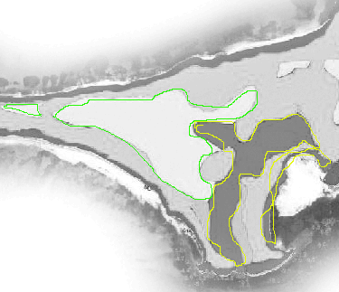
In this illustration based on the developer's own EIA, the areas outlined in green are inland mangroves and the areas outlined in yellow are coastal mangroves.It should be noted that a mangrove river, "Joes Creek" flows through this area and ends up in the sand bonefishing flats to the lower right.In this illustration, we depict the proposed marina per the developer's own plans.How is it possible that the developer is able to state in paid advertisements to the local media that: "Contrary to prevalent rumors, Joe's Creek, the mangroves and the Guana Cay bonefish flats will all be preserved and not altered by development."Later, the developer changed the wording of this on their saveguanacay.com website, to state, "The mangrove wetland known as Joe's Creek, and the Great Guana Cay bonefish flats, will not be altered by the Bakers Bay Club development."A inland estuaries expert, who resides part time on the island, is surprised by the developer's plans to build such a large marina.
Jim Alderman writes,"Gray water in most cases is water that has gone through some stage of wastewater treatment; that which comes from water not treated and with minimal human contact.
Laundry water is also called gray water."It is my understanding that Discovery is going to put their effluent (sink, wash, bath and sewage) through a primary and secondary sewage treatment and then use that effluent for irrigation.
Basically, the primary treatment is removal and separation of solids and secondary treatment involves some sort of biologic process (there are many) and aeration.
In total, the treatment plant there is a tertiary treatment that involves disinfectants.Land application of wastewater, no matter what treatment phase, still contains nitrogen and phosphorous, the N and the P that is on fertilizer bags; the K is potassium, hence the 10-10-10 or N-P-K use by everyone to fertilize lawns, etcetera."It is not impossible to remove the N and P but it is extremely expensive.Some of the N and P will be taken up by the plants but not nearly enough.
That which is not used will get into the ground water and travel laterally and seep into the ocean and the sea.I calculated the number of homes, condos, and hotel room, that showed how much N and P are produced per person per day times 365 allowing for total occupancy...I got the initial per person figures from our state DNR.
The bottom line is that gray water contains nitrogen and phosphors and some gets used and some gets into the water column and the in the water column and can cause algal growth on reefs."So the marina will be as dangerous to the coral reef as the dredging.But what the EIA fails to mention is that the marina, which cuts a hole into the island and ends up nearly abutting the beach on the Atlantic side of the island, will cut the island in half, ridding it of the mangrove ecosystem that protects the island against hurricanes.One direct hit of a hurricane, and flooding will occur in the area adjacent to the marina.
I have been dead center in an Abaco hurricane and seen the Atlantic waters rise by up to seven feet.
The narrow spit of land between the Bakers Bay development and the rest of the island can literally be flooding by hurricane-driven water.The hurricane could easily cut the island in half if the marina is built. The net effect on the island would be continued yearly degradation.
The coral reef, now open to the marina's foul water and the flooding receding back into the reef, will again be destroyed.It is interesting to note that the developer is not attempting to fight the scientific contention that it will destroy the reef and mangroves.Perhaps to them, none of that matters.
Bahamian cronyism will take care of that.December 19, 2005.Aerial photographs depicting the progress on Bakers Bay Golf and Ocean Club indicate that large portions of the mangroves have already been torn out.
It is unlikely that Guana Cay's mangroves will ever entirely recover after the developer has been removed from the Bahamas.
In this illustration, we depict the proposed marina per the developer's own plans.How is it possible that the developer is able to state in paid advertisements to the local media that: "Contrary to prevalent rumors, Joe's Creek, the mangroves and the Guana Cay bonefish flats will all be preserved and not altered by development."Later, the developer changed the wording of this on their saveguanacay.com website, to state, "The mangrove wetland known as Joe's Creek, and the Great Guana Cay bonefish flats, will not be altered by the Bakers Bay Club development."

A inland estuaries expert, who resides part time on the island, is surprised by the developer's plans to build such a large marina. Jim Alderman writes,"Gray water in most cases is water that has gone through some stage of wastewater treatment; that which comes from water not treated and with minimal human contact. Laundry water is also called gray water."
It is my understanding that Discovery is going to put their effluent (sink, wash, bath and sewage) through a primary and secondary sewage treatment and then use that effluent for irrigation. Basically, the primary treatment is removal and separation of solids and secondary treatment involves some sort of biologic process (there are many) and aeration. In total, the treatment plant there is a tertiary treatment that involves disinfectants.
Land application of wastewater, no matter what treatment phase, still contains nitrogen and phosphorous, the N and the P that is on fertilizer bags; the K is potassium, hence the 10-10-10 or N-P-K use by everyone to fertilize lawns, etcetera."
It is not impossible to remove the N and P but it is extremely expensive.
Some of the N and P will be taken up by the plants but not nearly enough. That which is not used will get into the ground water and travel laterally and seep into the ocean and the sea.
I calculated the number of homes, condos, and hotel room, that showed how much N and P are produced per person per day times 365 allowing for total occupancy...I got the initial per person figures from our state DNR. The bottom line is that gray water contains nitrogen and phosphors and some gets used and some gets into the water column and the in the water column and can cause algal growth on reefs."
So the marina will be as dangerous to the coral reef as the dredging.But what the EIA fails to mention is that the marina, which cuts a hole into the island and ends up nearly abutting the beach on the Atlantic side of the island, will cut the island in half, ridding it of the mangrove ecosystem that protects the island against hurricanes.One direct hit of a hurricane, and flooding will occur in the area adjacent to the marina.
I have been dead center in an Abaco hurricane and seen the Atlantic waters rise by up to seven feet. The narrow spit of land between the Bakers Bay development and the rest of the island can literally be flooding by hurricane-driven water.The hurricane could easily cut the island in half if the marina is built. The net effect on the island would be continued yearly degradation.
The coral reef, now open to the marina's foul water and the flooding receding back into the reef, will again be destroyed.It is interesting to note that the developer is not attempting to fight the scientific contention that it will destroy the reef and mangroves.Perhaps to them, none of that matters.
Bahamian cronyism will take care of that.December 19, 2005.Aerial photographs depicting the progress on Bakers Bay Golf and Ocean Club indicate that large portions of the mangroves have already been torn out. It is unlikely that Guana Cay's mangroves will ever entirely recover after the developer has been removed from the Bahamas.

But what the EIA fails to mention is that the marina, which cuts a hole into the island and ends up nearly abutting the beach on the Atlantic side of the island, will cut the island in half, ridding it of the mangrove ecosystem that protects the island against hurricanes.
One direct hit of a hurricane, and flooding will occur in the area adjacent to the marina. I have been dead center in an Abaco hurricane and seen the Atlantic waters rise by up to seven feet. The narrow spit of land between the Bakers Bay development and the rest of the island can literally be flooding by hurricane-driven water.
The hurricane could easily cut the island in half if the marina is built. The net effect on the island would be continued yearly degradation. The coral reef, now open to the marina's foul water and the flooding receding back into the reef, will again be destroyed.
It is interesting to note that the developer is not attempting to fight the scientific contention that it will destroy the reef and mangroves.Perhaps to them, none of that matters.
Bahamian cronyism will take care of that.December 19, 2005.Aerial photographs depicting the progress on Bakers Bay Golf and Ocean Club indicate that large portions of the mangroves have already been torn out.
It is unlikely that Guana Cay's mangroves will ever entirely recover after the developer has been removed from the Bahamas.