Sicily Map
A watercolor map of Sicily, painted in 2014 and updated for the Citrus Kingdom articles.
Updated September 29, 2026
Stories from Sicily: The Citrus Kingdom: Palermo · Cefalù · Taormina · Vendicari · Zingaro · Sicily journal
Sicily is the largest island in the Mediterranean, a rough triangle of limestone hills, citrus plains, and volcanic slopes anchored in the east by Mount Etna, the tallest active volcano in Europe. I painted this map in watercolor in 2014, and updated it in 2026 to accompany the new Citrus Kingdom articles.
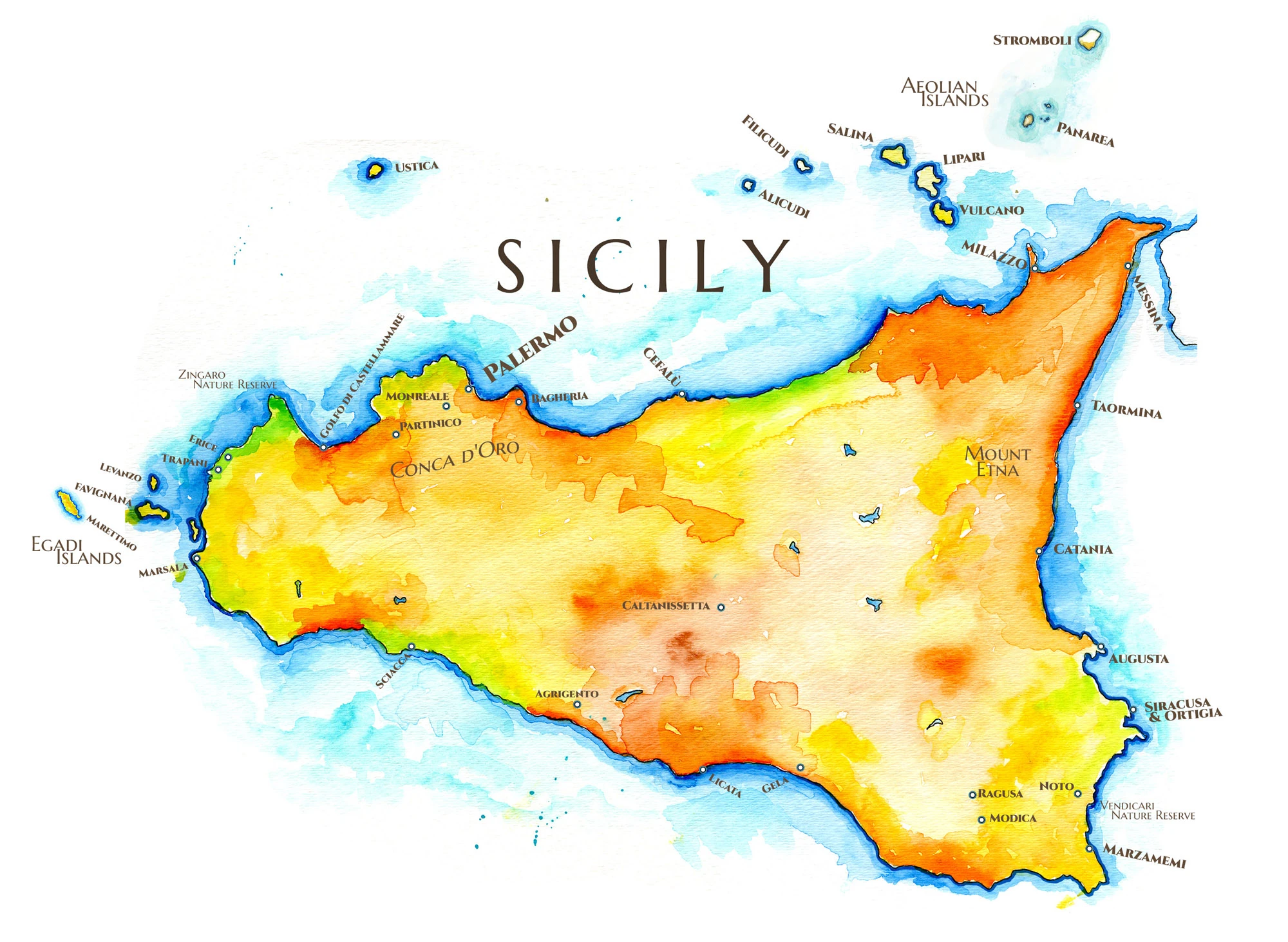
The Greeks called the island Trinacria, the three-cornered, for its three capes: Peloro at Messina, where the mainland is only a couple of miles across the strait, Passero in the far southeast, and Lilibeo at Marsala in the west. The north coast runs from Trapani and Erice past the Zingaro reserve and the Golfo di Castellammare to Palermo, set in the Conca d’Oro, the golden shell of citrus groves in the hills behind it, then on past Bagheria and Cefalù to Milazzo. The east is Etna’s coast, from Taormina down through Catania and Augusta to Siracusa and the island of Ortigia. The south faces Africa, from Noto, Modica and Ragusa past Gela, Licata and Agrigento to Sciacca, and the interior around Caltanissetta is dry wheat and sulfur country. Offshore lie Ustica, the Egadi Islands of Favignana, Levanzo and Marettimo, and the Aeolians to the north.
Nearly every Mediterranean power has ruled here. Greeks built Siracusa and the temples of Agrigento, Carthage held the west, and after Rome came Byzantines, Arabs, Normans and Spaniards. The Arabs brought the irrigation and the sour orange and lemon that made Sicily a citrus island. Some of its wild things are found nowhere else: the Sicilian wall lizard, and the Sicilian fir, reduced to a few dozen wild trees in the Madonie mountains.
My Travels in Sicily
On my first trip, I walked the old Arab quarter of Palermo and the coast to Zingaro, in The Bright Road to Zingaro. Years later, Jane and I returned with our friends Iva and Ivan and drove east from Palermo to Cefalù, Lipari and Taormina, the route of the four-part series that begins with Palermo and the Citrus Kingdom and ends beneath Etna in Taormina and the Volcano Oranges. My drawings from the island are in my Sicily Sketch Journal.
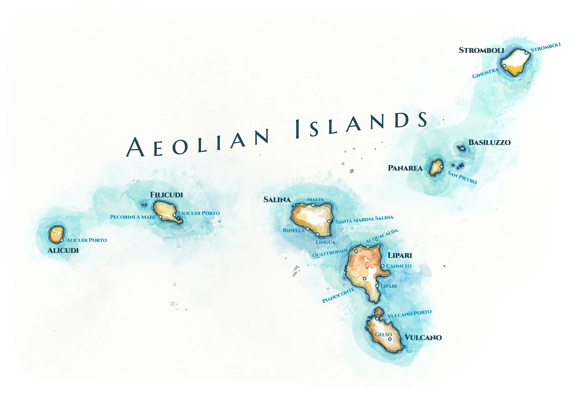
Aeolian Islands Map
The new Citrus Kingdom articles required a detail map of the Aeolian Islands, the chain of seven volcanic islands rising from the Tyrrhenian Sea off Sicily's northern coast. The original map is on the Aeolian Islands map page.