
Oregon Map
I painted this map of Oregon State in watercolors and natural pigments I found while traveling through the state.
Updated September 29, 2026
Stories from Oregon: The Columbia River · Zumwalt Prairie · Summer Lake · Malheur · The Alvord Desert · The Owyhee · Oregon journal
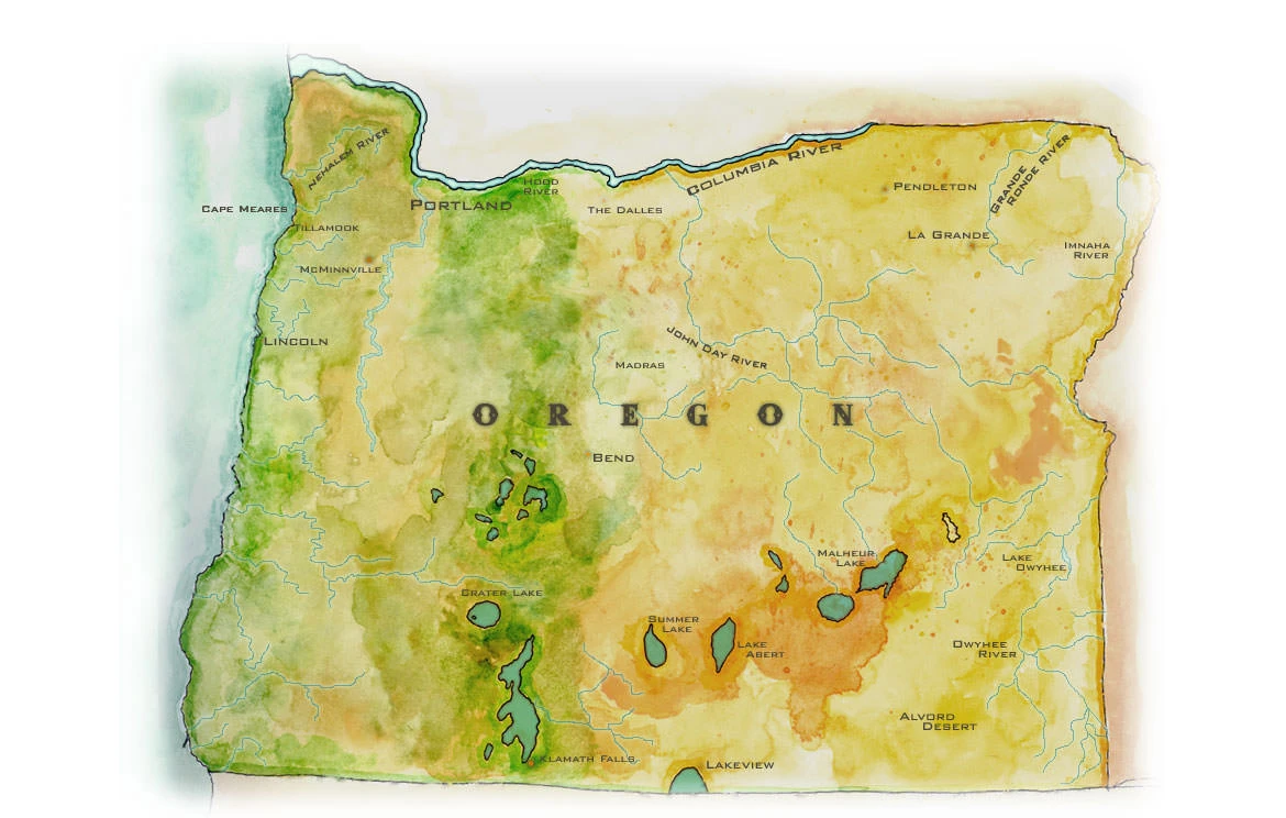
Oregon is a state divided by its mountains. On this map the Cascades run north to south as a band of green, from Hood River on the Columbia down past Bend and the blue eye of Crater Lake to Klamath Falls. West of them lies the wet Oregon most people picture: the Coast Range, the farm towns of the Willamette Valley, Portland at the meeting of the Willamette and the Columbia, and a coast of headlands like Cape Meares, where the Nehalem River and the dairy country of Tillamook meet the sea. East of the Cascades, nearly two-thirds of the state turns the ochre and orange of the high desert.
The Columbia River draws most of the northern border, cutting through the Cascades in its gorge and running on past The Dalles, where Oregon Trail emigrants once had to choose between rafting the river and hauling their wagons over the mountains. In the northeast corner, the Grande Ronde and the Imnaha drain the Blue Mountains and the Wallowas, and the John Day River winds across the center of the state. The southeast belongs to the Great Basin, where rivers never reach the sea. Summer Lake, Lake Abert and Malheur Lake are shallow, alkaline remnants of great ice-age lakes, and the Alvord Desert is a dry lakebed below Steens Mountain. The Owyhee River cuts its canyons through the far corner of the state.
Those desert lakes are some of the most important bird habitat in the West. The Malheur National Wildlife Refuge, set aside in 1908, is a stopover for sandhill cranes, white pelicans and waterfowl on the Pacific Flyway. People have been here a very long time. In the Paisley Caves near Summer Lake, archaeologists found human traces more than 14,000 years old, and at Fort Rock, sandals woven from sagebrush bark were buried under the ash of Mount Mazama, the volcano whose collapse made Crater Lake.
My Travels in Oregon
Many of my stories begin in Oregon. The Owyhee Puzzle starts with a stone tool on a promontory above the Owyhee River and follows it across the Alvord Desert and beyond. Malheur and the Golden Age of Travel takes me to the refuge just after the end of the Bundy occupation, and Magicians, Travel Writers and Summer Lake is a reflection on the craft from a cafe in the southern desert. In the far northeast, my younger brother and I stopped at the tavern in the canyon town of Imnaha on the way to the prairie in Thunder on the Zumwalt Prairie.