
The Baker's Bay Golf Course Guidelines
The developer’s rules for a golf course beside a coral reef never mention the reef. They were never finished, either.
October 4, 2026
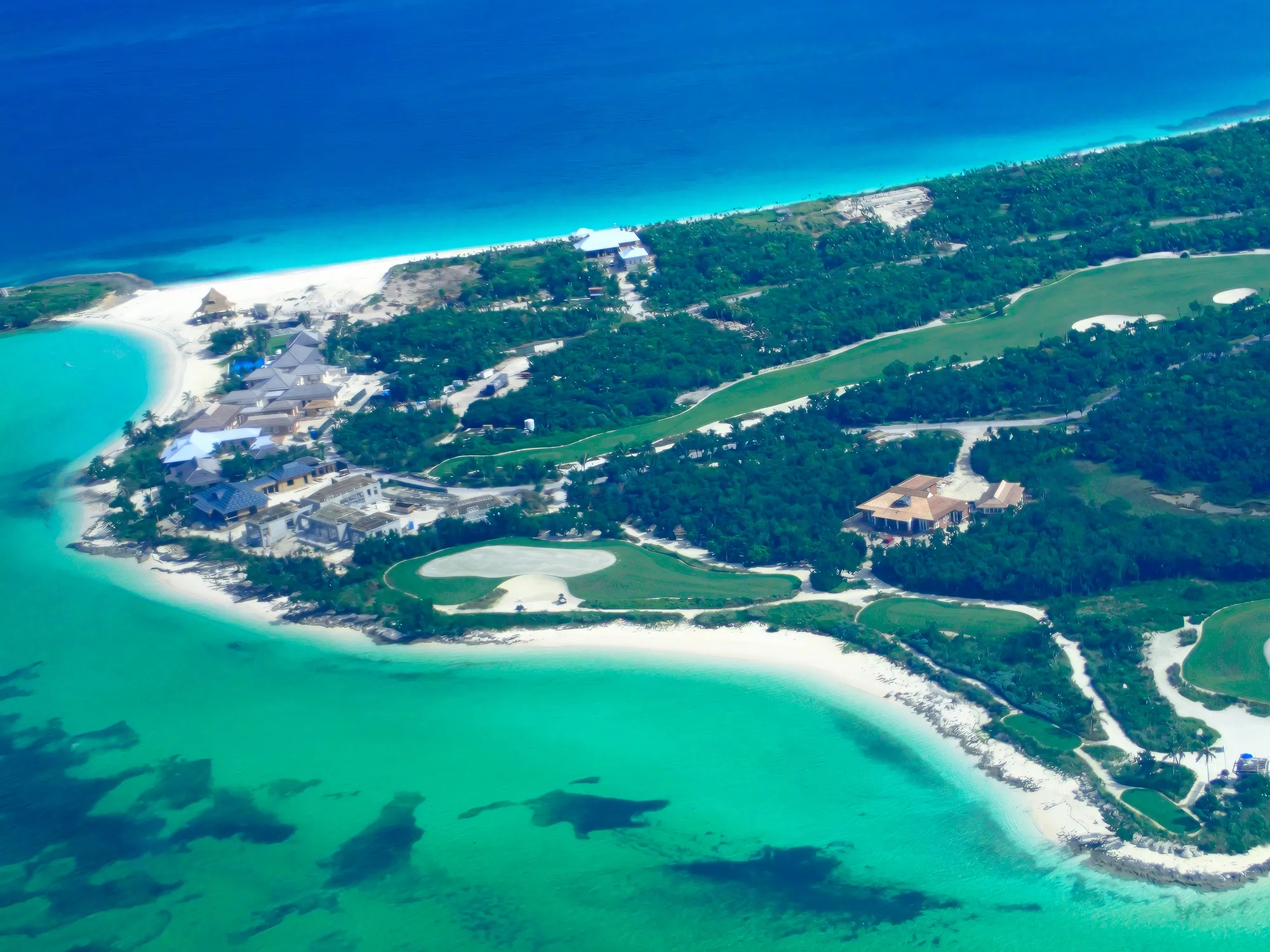
Among the Baker's Bay papers is a twelve-page document titled Baker's Bay Golf Course Best Management Practices and Environmental Guidelines. It was the developer's answer to the question everyone on Great Guana Cay was asking: what would an eighteen-hole golf course do to the reef a few yards away? This page reads the guidelines against their own words, and against what scientists found on the shore once the course was built.
A Draft With the Notes Still In
The guidelines are undated, and they were never finished. Two notes from the drafting process are still sitting in the text. The first comes right after a list of steps the document says have already been completed, including “response plans for environmental emergencies such as spills and major storm events.” In capital letters, the next line asks:
“LIVINGSTON - DO WE HAVE An ERP OR INSERT CHEMICAL SPILL RESPONSE IN THE CONTINGENCY PLAN SECTION OF THIS DOCUMENT…WHEREVER THE STORM EVENT PLAN IS.”
The emergency plan the document lists as done is, a few words later, a question: does one exist? Livingston is Dr. Livingston Marshall, the Baker's Bay executive to whom the University of Miami's monthly monitoring reports were addressed.
The second note comes at the exact point where the guidelines should say how much fertilizer and pesticide the course would use. The sentence explains that chemical use depends on the turf, the site and the season, and that a test plot of seashore paspalum “will be incorporated to determine the specific…” and then stops: “..KATHLEEN PLEASE INSERT.” Kathleen is Dr. Kathleen Sullivan-Sealey, who led the University of Miami team behind the Environmental Impact Assessment and the Environmental Management Plan. Nothing was inserted. The one number that decides what a golf course does to a coral reef is a blank.
The four appendices the guidelines rely on — the liner plan, the erosion control measures, the drainage details and the revegetation map — are listed at the end but not included.
What the Guidelines Promised
On paper, the commitments are specific:
- Liners. The golf course lake would be lined with a 30mm liner, and seven areas with a 20mm liner: the greens of holes 8, 12 and 17, the tees of hole 10, and all of holes 9, 13 and 18.
- Drainage. Greens would be “designed to drain inward to a centralized drainage system,” into vegetated lakes and retention ponds, so that nothing ran off toward the sea.
- Buffers. Native vegetation would surround “all golf holes” and “all water features,” and would be “the primary means to mitigate the impacts of construction and operation of the golf course.”
- Fertilizer. It would never be applied “around water bodies or adjacent to watercourses,” slow-release nitrogen would be used where possible, and an Integrated Pest Management plan would keep chemicals to a minimum.
- Everything else. Composting toilets throughout the course, an on-site weather station, mulched cart paths instead of pavement, and storage of chemicals to “US EPA and State of Florida standards.”
What the Guidelines Admitted
The most candid page in the document is its own impact table, borrowed from the 2004 EIA. Of the property's 372 acres, it says, “about 40% will remain in small patches and corridors.” The forest loss is rated “Irreversible”: “It is unlikely that a forest will ever recover from the golf course conversion, even if site is abandoned.” It names “a KEY CONCERN” in the brackish water that seashore paspalum can be irrigated with. And it concedes that buffer zones “cannot be considered to be 100% effective.”
Then it scores the overall significance as “Moderate,” and the reason it gives is worth reading twice: “The current infestations of fire ants and lobate lac scale do pose a threat to native plants and wildlife, thus the management development does offer better long-term stewardship of island biological diversity, with removal of invasive pest species.”
In other words, bulldozing most of a forest is good for the forest, because the forest has bugs.
It is hard to imagine a worse argument. Fire ants are creatures of open, disturbed ground. They do poorly under a closed forest canopy, and they thrive in exactly what a golf course makes: cleared land, bare soil, and irrigated turf mowed short in full sun. They also travel in soil, sod and nursery plants, which is why the United States has restricted the movement of sod and nursery stock out of fire-ant country for decades. The guidelines themselves describe a construction site where soils are “removed, imported and compacted,” and where the finished ground is laid with sod. A golf course is not a cure for fire ants. It is fire-ant habitat, and a delivery system.
Getting rid of fire ants on a golf course is not a gentle business, either. On turf they are killed with insecticide baits and granules, and some of the most widely used, such as bifenthrin and fipronil, are highly toxic to shrimp, crabs and other aquatic invertebrates. On porous limestone a few yards from a reef, the “environmental benefit” arrives as more pesticide.
The lac scale argument is no better. The lobate lac scale is a real pest of native Bahamian trees, but the cure on offer is to clear most of the trees it was attacking. And after counting both insects in the developer’s favor, the document never mentions either one again. Its pest management section defines pests as anything that would “destroy or reduce turfgrass quality.” There is no fire-ant program and no lac scale program. The only pests the guidelines plan to manage are the ones that hurt the grass.
What the Guidelines Leave Out
The words “coral” and “reef” do not appear anywhere in the document. Neither does “seagrass.” “Marine” appears three times, always in passing. A set of environmental guidelines for a golf course built beside one of the most important reefs in the northern Bahamas never mentions the reef.
What the document is really about is construction: silt fences, mulch bales, gravel entrances, temporary seeding, sod. Erosion control, it says, is “the single most important needed sensitivity of the construction process.” That is true of a construction site anywhere. It is not the main threat on Great Guana Cay.
The main threat is groundwater. The island is porous limestone with almost no soil, and whatever is put on the turf moves down into the water table and out to sea, continuously, whether or not anything visibly runs off (see why golf courses and coral reefs are incompatible). The guidelines mention groundwater, but treat it as a drainage problem to be handled with liners on part of the course and ponds that “abate excess nutrients.” There is no nutrient limit for the water offshore, no fertilizer rate, no measurement of what reaches the reef, and nothing that would stop or change the course's operation if the reef began to decline. As Dr. Michael Risk put it in his 2004 assessment: “It is, however, impossible to grow grass without water, and impossible to grow golf course grass without fertilizer. No matter how well the use of these two is monitored, some will inevitably escape to the sea.”
Even the standards are borrowed. Chemicals would be stored and used according to the rules of the United States and Florida, not the Bahamas, and not any standard written for a reef.
What Was Found on the Shore
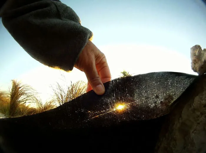
In January 2012, Dr. Thomas Goreau, Dr. James Cervino and Troy Albury of Save Guana Cay Reef surveyed the shoreline below the finished course. Their findings are in Bakers Bay Golf Course and Coral Reef Decline. Where the greens come closest to the sea, they found the guidelines' three main protections missing or failing:
- The greens sit just inland from the shoreline, five to ten feet above the water, so groundwater flows downhill toward the sea rather than inward to any central drain.
- The vegetation buffer was “totally absent or very sparse in many places.”
- Where the liner could be seen from the beach, only one short stretch was an impermeable rubber barrier. More than 95% of it was “an open permeable mesh that retains sand but allows rain and ground water runoff to pass right through it.”
The promise that fertilizer would never be applied “around water bodies or adjacent to watercourses” meant nothing on the ground. The course runs right up to the water and sits beside the reef, as the photograph at the top of this page shows. I have watched that stretch of the course being fertilized. A green that ends at the beach is fertilized at the beach.
A video by Troy Albury of Save Guana Cay Reef shows just how close the course comes to the water.
Video: Troy Albury, Save Guana Cay Reef. The Baker’s Bay golf course at the water’s edge.
Directly below the greens, a bright band of green and red algae and cyanobacteria mats coated the beach rock, thinning out with distance from the course. Reefs nearby showed weedy algae overgrowing coral, and new disease outbreaks.
Two years later, at the Abaco Science Alliance Conference in January 2014, the same three presented nitrogen analyses of 80 algae samples collected from 2011 to 2013. Algae near the golf course had the highest nitrogen content at every sampling. Its isotopes pointed to a sewage origin, which the authors suggested came from slow-release organic fertilizer made from recycled sewage — the same “slow-release nitrogen” the guidelines had offered as a safeguard.
Why It Matters
Read today, the guidelines look like the rest of the Baker's Bay paper trail: thorough in form, careful about the things that are easy to manage, and silent on the thing that mattered. They treated the golf course as a construction site to be kept tidy, not as a permanent source of nutrients sitting on porous rock above a reef. The fertilizer rate was left blank. The emergency plan was a question in capital letters. And the protections the document did specify — inward drainage, liners, buffers — were, at the island's northwest tip, not what was built.
Read the Full Document
The full text is transcribed below, and the original is available as a PDF: Baker's Bay Golf Course Best Management Practices and Environmental Guidelines (PDF). For the plans they were meant to serve, see the Environmental Impact Assessment and the Environmental Management Plan; for what the University of Miami's monitoring team actually recorded, see the Baker's Bay monitoring reports.
The Full Text of the Guidelines
Below is the complete text of the guidelines, transcribed from the twelve-page original. The wording, spelling and gaps are left as written, including the two drafting notes, which are highlighted. Page numbers are omitted, and the four appendices were never attached.
Read the full text of the Baker’s Bay Golf Course Guidelines
Baker’s Bay Golf Course Best Management Practices and Environmental Guidelines
A. Background
The design and management of the proposed Baker’s Bay Golf (BBC) and Ocean Club Golf Course outlines a prescriptive approach, based on a-priori specification of Environmental and Best Management Practice’s (BMP’s), detailed here. Development in sensitive environments, such as the property of Baker’s Bay Club, must begin with an environmental inventory and an understanding of site attributes, their functions and interactions. This was accomplished for the BBC Environmental Impact Assessment (EIA) in 2004, lending a scientific aspect to the golf course design and management plan. Based on the ecology, geology and meteorological conditions of the property, the EIA identified BMP’s which will be followed for the construction, design and management of the golf course. BBC strives to demonstrate BMP’s to reduce the threat of Non-Point Source (NPS) Pollution to terrestrial, marine and wetland resources.
Golf Course Best Management Practices – Development
Thus far, the Golf Course development process has included the:
- Completion of a Pre-Development Environmental Impact Assessment
- Identification of Environmentally Sensitive Areas and Constraints
- Co-ordination of input from the developers, the architects, engineers, environmental specialists and review authorities
- Acquisition or request of the necessary legislated approvals
- Outline of a golf course management and monitoring program defining BMP’s for the construction and operations phase, mitigation techniques, turf grass maintenance, irrigation, pesticide and fertilizer use, sediment control, maintenance of buffers, naturalized areas and wetlands
- Completion of response plans for environmental emergencies such as spills and major storm events. (LIVINGSTON -DO WE HAVE An ERP OR INSERT CHEMICAL SPILL RESPONSE IN THE CONTINGENCY PLAN SECTION OF THIS DOCUMENT…WHEREVER THE STORM EVENT PLAN IS.)
B. Construction and Design
The construction of the golf course will undoubtedly alter the ecology of the property. However, by following proper BMP’s for construction and design impacts can be minimized. The most important ecological impacts to manage and mitigate for include:
- Loss or degradation of habitat for terrestrial and marine species,
- Introduction of fresh water and nutrients to island hydrology, and
- Introduction of land-based sources of pollutants and contaminants.
Table 1 outlines an impact matrix (EIA, 2004) to assess and mitigate the potential golf course impacts. Acknowledging and outlining these likely impacts previous to construction allows for preparedness and best suited-mitigations.
| Qualitative Criteria | Choices | Description |
|---|---|---|
| NATURE | Direct | Land cover alteration from shrub thicket and forests to open grassy areas will directly impact the overall plant diversity on the island |
| TYPE | Negative | Large area of continuous Broadleaf Evergreen Forest will be fragmented and converted to turf-grass fairways and greens. Of the original 372 acres, about 40% will remain in small patches and corridors. Patches of vegetation do not offer the same ecological value as a contiguous forest, and thus wildlife habitats and plant diversity may be lost. |
| Positive | Upland vegetation communities will be fragmented, but a management program for the lobate lac scale will help control the current infestation on native trees, | |
| LIKELIHOOD | Certainty | Impacts will occur with land conversion to golf course. |
| SCALE | Habitat–specific impact | Impacts are the further fragmentation of the contiguous coppice (broadleaf evergreen forest) areas. This fragmentation may lead to a long-term loss of plant diversity if not monitored. There are very specific threats to the groundwater quality throughout the project site. |
| DURATION | Long-term | Impacts will be more acute with construction, with some recovery of trees and vegetation with time. A KEY CONCERN is the use of Paspalum grasses that can grow with brackish water. This increased salinity of irrigation water, or contamination of ground waters may lead to the demise of native vegetation. |
| REVERSIBILITY | Irreversible | It is unlikely that a forest will ever recover from the golf course conversion, even if site is abandoned. |
| OVERALL SIGNIFICANCE | Moderate | This is a moderate impact overall on the project site. The current infestations of fire ants and lobate lac scale do pose a threat to native plants and wildlife, thus the management development does offer better long-term stewardship of island biological diversity, with removal of invasive pest species. |
Golf Course Best Management Practices – Design and Construction
Important guidelines and BMP’s to be followed for the design and construction of the golf course to minimize ecological impact that include:
- Sites have been selected and designed to allow the golf course to be routed in such a way as to minimize the need to alter or remove existing native landscapes, trees, and vegetation, and which provide opportunities for restoration/enhancement of valuable habitat.
- Natural rock outcroppings that are archaeologically or geologically significant, and sensitive or critical habitat (e.g. wetlands) and environmental features will be preserved through careful golf course design.
- Representatives of each vegetation habitat on the island will be protected throughout the course area; this includes grassy wetlands, coppice and broadleaf evergreen forest communities.
- The site plan has identified areas for restoration, replanting, and enhancement of disturbed habitat to re-establish wildlife migration corridors and linkages between fragmented habitat areas. This includes areas dominated by Australian pines and coconut trees that will require some restoration.
- Buffers of natural vegetation or “no cut” areas of rough where sensitive features cannot be avoided will be included. Areas between fairways will retain and restore existing native vegetation, where possible (see Section D).
- Native habitats and communities of special value to threatened/endangered species will be preserved to the greatest extent possible
- The site drainage plan will be centralized and drain to vegetated areas.
- Fairways in sensitive areas will be lined to minimize nutrient run-off and Nonpoint source pollution (Appendix 1).
- Drainage ponds will be developed mimicking natural conditions in terms of both aesthetics and habitat, to the extent feasible.
Erosion management
Erosion control is the single most important needed sensitivity of the construction process. Vegetation is removed, soils are exposed, removed, imported and compacted and a tight time schedule is followed. The BBC site is vulnerable to extreme storm events and during construction and planned mitigations, contingency plans and control measures have been outlined (Appendix 2). In order to protect significant natural features from negative impacts due to sedimentation during construction, a sediment and erosion control plan that illustrates the measures that are to be taken is being prepared. The EIA (2004) outlined the following BMP’s and sediment controls, several of which will be incorporated into the design and construction process:
- Grassed Waterways and Swales: This practice involves using grassed surfaces to reduce runoff velocities, enhance infiltration and remove runoff contaminants, thus improving runoff quality and reducing the potential for downstream channel degradation and sediment pollution.
- Temporary Gravel Construction Entrance: A gravel pad, located at the points of vehicular ingress and egress on a construction site, to reduce the mud transported onto public roads and other paved areas.
- Mulch Bale Barriers: A temporary sediment barrier composed of native mulch placed across or at the toe of a slope to intercept and detain sediment and decrease flow velocities from drainage areas of limited size.
- Silt Fences: A temporary sediment barrier constructed of posts, filter fabric and, in some cases, a wire support fence, placed across or at the toe of a slope or in a minor drainage way to intercept and detain sediment and decrease flown velocities from drainage areas of limited size.
- Temporary Sediment Trap: A small ponding area, formed by constructing an excavated shallow area or earthen embankment with a gravel outlet across a drainage swale, to detain sediment-laden runoff from small disturbed areas for enough time to allow most of the sediment to settle out.
- Riprap: A permanent, erosion-resistant ground cover of large, loose, angular stone usually underlain by erosion matt of filter fabric installed wherever soil conditions, water turbulence and velocity, expected vegetative cover, etc., are such that soil may erode under storm water flow conditions.
- Temporary Seeding: Establishment of temporary vegetative cover on disturbed areas by seeding with appropriate rapidly growing plants on sites that will not be brought to final grade for a period of 30 days.
- Permanent Planting: Establishment of perennial vegetative cover by planting seed or native plants from the on-site nursery area on the rough graded areas that will not be brought to final grade for a year or more or where permanent, long-lived vegetative cover is needed on fine graded areas.
- Sodding: Stabilizing fine graded areas by establishing permanent grass stands with sod. This provides immediate protection against erosion, and is especially effective in grassed swales and waterways or in areas where an immediate aesthetic effect is desirable.
Golf Course Best Management Practices – Erosion Control
Important guidelines and BMP’s to be followed for the design and construction of the golf course to minimize erosion problems:
- Erosion and sediment control measures are to be placed prior to, or as the first step in, construction. Sediment control practices will be applied as a perimeter defense against any transportation of silt and/or water turbidity off the site. The contractor shall provide a plan and written notice to the owner and engineer 10 days prior to commencing work. The contractor shall accept and will be responsible for maintaining existing erosion control facilities.
- Silt screens and turbidity barriers must remain in place and in good condition at all locations shown in the plans and as required until the contract is completed and soils are stabilized and vegetation has been established.
- The erosion control measures set forth in the plans are intended as minimum standards. Any erosion control requires beyond that specified shall be considered as included within the contract.
- Materials from work shall be contained, and not allowed to collect on any off-site perimeter areas or in waterways. These include both natural and man-made open ditches, streams, storm drains, lakes and ponds.
- Weekly, or after raining, inspections shall be made by the contractor to determine the effectiveness of these efforts. Any necessary remedies or repairs shall be performed without delay and at no cost to the owner.
- All mud, dirt or other materials tracked or spilled onto existing roads and facilities from the site, due to construction, shall be promptly removed by the contractor/builder. Deviation from this will cause Owner notification, and all work will stop until corrected.
- Permanent soil erosion control measures for all slopes, channels, ditched or any disturbed land areas shall be completed immediately after final grading. When it is not possible to permanently protect a disturbed area immediately after grading operations, temporary erosion control measures shall be installed. All temporary erosion control measures shall be maintained until permanent measures are in place and established. Temporary erosion control may consist of but not be limited to grass, sod, mulch, sand bags, piping, slope drains, settlement basins, artificial coverings, berms, hay bales, straw and dust control.
- All erosion prevention and control measures must be inspected and approved by the Owner prior to any construction activities. Removal of these same erosion controls and prevention measures may be done only after authorization by the Owner is obtained.
- In the event that the erosion prevention and control devices shown on the plans prove not to be effective, alternate methods for maintaining water quality standards for discharge from the construction site will be required. The Owner prior to placement must approve all alternate erosion prevention and control devices.
C. Lining and drainage
Golf courses rely heavily on water for the maintenance of the turf areas and accordingly there is potential for disturbance of the natural water quality of the property. A main objective of the golf course development is to maintain pre-development water quality conditions. This is important in order to minimize impacts on the natural features and adjacent to the property and protect areas that may rely upon the natural water quality.
The location of golf courses near the coastline causes concern about NPS pollution effects on the water quality of surrounding marine and wetland environments. Of particular interest is the impact of herbicides, fungicides and fertilizers on groundwater quality. Golf courses are intensive production systems, and the frequent mowing and application of fertilizers or pesticides requires careful management to avoid damage to the surrounding environment. Nitrogen, phosphorus and many pesticides are potential pollutants of groundwater, and monitoring of their movement from turf grass areas to receiving waters is needed. In coordination with the drainage plan, several areas have been deemed environmentally sensitive, thus requiring lining (Appendix 1) to alleviate these potential impacts.
The golf course lake and certain holes will be lined to abate nutrient seepage and run-off. A 30mm liner will be used for the lake and a 20mm for the areas listed below. Lining has been agreed to be placed on the following holes and/or tees (Appendix 1):
- The greens of hole 8
- All of hole 9
- The tees of hole 10
- The greens of hole 12
- All of hole 13
- The greens of hole 17
- All of hole 18
Golf Course Best Management Practices – Drainage
Important guidelines and BMP’s to be followed pertaining drainage include:
- Surface waters and wetland features have been delineated and their on-site linkage to off-site investigated
- Pre-development water quality and weather conditions are being investigated to determine baseline conditions.
- Designing site drainage to maximize infiltration and mimic pre-development conditions.
- Using buffer zones around all water bodies to intercept runoff
- An on site weather station will be installed to make monthly/seasonal estimates of precipitation, evapotranspiration, infiltration and runoff.
- Vegetated buffer zones will outline greens and water bodies.
- Greens are designed to drain inward to a centralized drainage system.
- Greens will drain to vegetated lakes or vegetated retention ponds.
- A locally compatible, salt-water tolerant species of turf will be utilized to minimize water needs and utilize gray water.
- Signage and educational materials will be place in the buffers to make them nature education features
D. Buffer zones
An overall environmental goal of the Baker’s Bay Club development is to maintain a viable representation 80% of the natural vegetation communities on the island. Native buffer zones will be incorporated into the design of all golf holes and surround all water features on the BBC golf course to meet this goal. The design of native buffer zones around all water features and greens will be the primary means to mitigate the impacts of construction and operation of the golf course. Buffer zones function by:
- intercepting surface run-off to decrease peak storm runoff to surface waters;
- promoting infiltration into non-compacted soils;
- enhancing bank stability;
- trapping sediments and related surface-bound contaminants;
- advancing uptake of nutrients into vegetation;
- providing habitat and corridors for native flora and fauna; and
- providing shade and coarse organic detritus to aquatic habitat.
Buffer zones may take one of three forms, listed here in decreasing order of preference:
- natural areas which are not disturbed at any stage of design or construction are the preferred design characteristics for the protection of surface waters;
- if disturbance cannot be avoided then areas which are naturalized with native species of vegetation after construction are an option; and
- at the minimum, areas of no or reduced mowing are better than manicured turf or the protection of surface water. (Gartner Lee Limited, 2001)
Buffer zones, whether natural or planted, have been cited as effective means of reducing phosphorus and sediment transport from source areas such as urban development, logging activities or feedlots. A paper by Woodard and Rock (1995) measured sediment and phosphorus attenuation from urban areas by natural forest buffer zones on steep and shallow slopes in Maine. Although in a different environment, on average, a 15m vegetated buffer zone reduced phosphorus concentrations of 1 - 9 mg/L to “background” levels (0.7 - 2.0 mg/L). The slope of the monitored area (1 - 5% vs. 10 - 15%) had little influence on attenuation but maintenance of ground cover in the source areas was highly effective. Phosphorus in runoff was reduced, from 5 - 9 mg/L to 1 - 2 mg/L as lawns became established.
While the environmental benefits are widely accepted, quantitative and relevant studies of their effectiveness are few and buffer zones cannot be considered to be 100% effective in mitigating for the habitat losses entailed. Thus, all efforts will be made to minimize the use of excess water and chemicals (Environmental Management and Monitoring Plan, Section E).
E. Vegetated Retention Ponds and Revegetation
An integral part of the drainage plan for the BBC proposed golf course are vegetated retention ponds. The holes will drain to these filtering ponds and lakes to abate excess nutrients. The vegetated retention ponds are slated be designed by a specialized consultant. The ponds would be dominated around the edged by native grasses and sedges such as Cyperus planifolius, Sand Cyperus, Spartina spp. and Cladium jamaicense. Larger shrubs and trees will be planted in areas of occasional flooding and low-lying areas of moist or wet soils (especially during the rainy season) (Table 1).
| Scientific Name | Common Name | Nativity | Wetland Conditions |
|---|---|---|---|
| Acrostichum aureum | Giant Fern | Native | Moist |
| Acrostichum danaeifolium | Giant leather fern | Native | Moist |
| Andropogon longiberbis | Broom sedge | Native | Standing Water |
| Annona glabra | Pond apple | Native | Standing Water |
| Avicennia germinans | Black Mangrove | Native | Wet Soil |
| Baccharis angustifolia | False Willow | Native | Wet Soil |
| Batis maritima | Saltwort | Native | Wet Soil |
| Chrysobalanus icaco | Cocoplum | Native | Wet Soil |
| Cladium jamaicense | Sawgrass | Native | Standing Water |
| Coccothrinax argentata | Silver Thatch, Silver-top, Bay-Top | Native | Moist |
| Conocarpus erectus | Buttonwood | Native | Wet Soil |
| Erithalis fruticosa | Black Torch | Native | Moist |
| Heliotropium curassavicum | Seaside Heliotrope, Pondweed | Native | Wet Soil |
| Hydrocotyle sp. | Marsh pennywort | Native | Wet Soil |
| Laguncularia racemosa | White Mangrove, Bastard Buttonwood, Green Turtle Bough | Native | Standing Water |
| Rhizophora mangle | Red Mangrove | Native | Standing Water |
| Spartina patens | Saltmeadow Cordgrass | Native | Standing Water |
| Spartina spartinae | Gulf Cordgrass | Native | Standing Water |
| Thrinax morrissii | Small-fruited Thatch-palm, Buffalo-top | Native | Moist |
| Typha domingensis | Cattail | Native | Standing Water |
Additionally, much of the golf course area has been disturbed by invasive species and is need of restoration. These areas along with the buffer zones and those altered by construction will be revegetated and landscaped with native vegetation (Appendix 4).
E. Water quality and Waste management
A main objective of BBC development is to maintain pre-development water quality conditions. Throughout the proposed golf course area, ground and near shore water quality is of critical concern due to the sandy soil and near-surface groundwater. Concerns with the interaction of golf course development with surface waters relate to site runoff and the potential for erosion, and the transport of sediment, nutrients, or pesticides to surface waters. These impacts can be minimized through BMP’s, technology and site design. Techniques such as: a) underdrain systems or some other approved means for capturing and directing leachate away from ground water, and b) directing flow from underground drains to peat-sand filters in areas of permeable soils to ensure adequate filtration will be used (Appendix 2).
Composting toilets are very appropriate for situations such as BBC, where water use must be minimized and there is a severe need to remediate nutrient loading. Thus, composting toilets are being recommen for the golf course and permits will be applied for. Composting toilets can be used to alleviate eutrophication problems caused by nitrogen and phosphorus in ground and coastal waters. While composting toilets do very little to change the quantity of the major nutrients (nitrogen and phosphorus) in they can:
- Reduce the volume of solid waste by turning it into compost;
- Prevent the addition of pathogens to the groundwater by removing human waste from the septic system; and
- Significantly reduce water consumption.
Golf Course Best Management Practices – Water quality and Waste management
Important guidelines and BMP’s to be followed to manage water and waste include:
- Paved areas will be limited in order to minimize impermeable surfaces and, thereby, reduce surface runoff. When possible, cart paths will be mulched and not paved.
- The golf course will be graded such that water either infiltrates or runs off in a diffuse manner.
- Lined artificial storage ponds will not be located in prime groundwater recharge areas
- Impervious liners will be used for detention/retention ponds and water hazards to protect ground and surface water quality. Areas of critical concern on the golf course can use water-retaining buffers underground (“aquacludes”).
- Buffer strips, oil/grease separators or other recommended techniques for parking area drainage systems.
- Grease traps and other recommended technologies for facilities such as golf cart maintenance or wash areas to prevent untreated runoff from entering the natural groundwater environment.
- A state-of-the-art irrigation systems with site meteorological monitoring capability should be installed to minimize water use.
- The overall drainage system is designed to insure that there is no increase in the velocity or amount of off-site flows during major storm events.
- Composting toilets will be installed throughout the course.
F. Integrated Pest Management and Chemical usage
On site Environmental Management will address Integrated Pest Management Practices as BMPs during the operational phase of the course. The term ‘pests’ includes diseases, fungi, weeds, insects, and animals that destroy or reduce turfgrass quality. The goal of Integrated Pest Management (IPM) is to limit pest populations to sufficiently low thresholds to avoid economic damage to golf course operations with the least possible hazard to people, property, and the environment. The IPM favors natural pest manipulation by selecting proper turfgrass, seeding, irrigation, and fertilization practices, however it does not exclude chemical controls when required. A qualified pest control advisor certified in groundwater protection should prepare a plan for the course which minimizes or avoids potential adverse impacts to surface water or ground water.
Chemical use, and cutting requirements vary depending on the turf grass type, the specific site environs and weather, and season thus a test plot utilizing the chosen sea grass paspallum strain will be incorporated to determine the specific…..KATHLEEN PLEASE INSERT.
Fertilizers and pesticides are an integral part of golf course turf management. The monitoring strategy will combine routine weekly inspections with increased monitoring, as required, to identify pest conditions at early stages and evaluate pest treatment effectiveness. Populations can then be contrasted to established threshold levels to decide appropriate action and treatment, if required. The main objective for fertilizer and pesticide management is to ensure that they are used in response to needs demonstrated by a monitoring program and not used in broad application as a “preventive” measure.
One of the major concerns of excess fertilization is nitrogen and phosphorus migration by surface runoff. Newly seeded and erosion sensitive areas as well as damaged turf areas have the highest potential for elevated nutrient concentrations in runoff. Thus, fertilization will be minimized in these areas. As well, slow-release nitrogen fertilizers will be used where possible as this will minimize the potential for increased concentrations of nitrogen in surface runoff.
Golf Course Best Management Practices – Chemical usage
Important guidelines and BMP’s to be followed for chemical usage:
- Integrated Pest Management plan will be employed to insure judicious use of pesticides, which will be applied by certified applicators.
- Treatment thresholds will be defined prior to application. Treatment thresholds must be clearly established to assure that pest problems are kept under control, but also to prevent treatment when it is not required and not economical.
- Measures to reduce the potential for pesticide loss by: specifying stringent controls over timing and application rate of pesticides; using non-chemical or proven biological control methods as the preferred alternative to chemical pesticides
- Detailed trigger mechanisms for pesticide use will be specified, such as:
- high temperature and humidity to control soil fungi outbreaks;
- weed observations at a pre-determined density;
- soil monitoring results indicating pesticide application is required; and
- site-specific information that indicate a lifestage of a specific pest is likely to harm the turfgrass.
- Fertilizers will not be applied during dry soil conditions and/or prior to major rainfall events, and never around water bodies or adjacent to watercourses.
- Periodic soil testing should be done to determine nutrient requirements of the soils.
- To minimize the need for chemical application, turf areas will be of sufficient size to accommodate the use, but should allow for native vegetation to remain between fairways.
- Drainage design and buffers will be utilized to minimize any adverse impacts of runoff.
- Storage and use of pesticides, herbicides, and fertilizers will be limited to and in conformance with US EPA and State of Florida standards. Chemical use is minimized through spot treatment and applicators are licensed and trained in all safety-related aspects of chemical use.
- Storage, mixing and disposal of pesticides only in secure areas; and implementation of plans to prevent and mitigate spills.
- Advanced technology/monitoring equipment will be used to insure minimal application of pesticides, herbicides, and fertilizers.
- Slow-release, less soluble, and least mobile chemical fertilizers, pesticides, and herbicides available is encouraged. These products should be used at the smallest rates of active ingredient to accomplish the desired result.
- A drought, pest, and disease resistant grass species has been selected.
- Natural buffer areas will maintained by minimizing the use of fertilizers, pesticides, and herbicides.
References
- Environmental Impact Assessment for Baker’s Bay Club. University of Miami. 2004.
- Gartner Lee Limited. Best Management Practices and Guidelines for the development and Review of Golf Course Proposals. September, 2001
- Woodard, S.E. and C.A. Rock, 1995. Control of residential storm water by natural buffer strips. Lake and Reserve. Manage. 11: 37-45.
- Appendix 1. Liner plan for the golf course.
- Appendix 2. Erosion control measures.
- Appendix 3. Drainage and storm sewer details.
- Appendix 4. Revegetation map.